Data
- Obtaining
- Supplying
- High-Frequency
- Bottom Pressure Records
- Other Long Records
- GLOSS/ODINAFRICA Calibration Data
Donate
Donate to PSMSL
Data Notes
- Individual Station Data and Plot Notes
- Referencing the Data Set
- PSMSL Help File
- 2010 Changes to the PSMSL Data Files
Extracted from Database
03 Mar 2025
Station Information
| Station ID: | 1001 |
| Latitude: | 18.458333 |
| Longitude: | -66.115 |
| GLOSS ID: | 206 |
| Coastline code: | 938 |
| Station code: | 21 |
| Country: | PUERTO RICO |
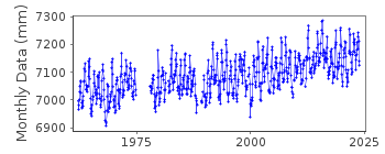
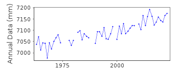
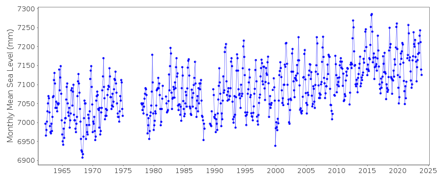
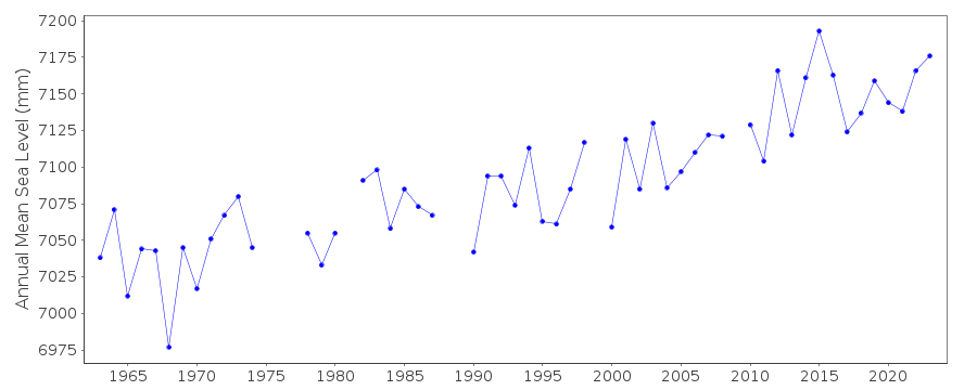
| Time span of data: | 1962 – 2024 |
| Completeness (%): | 92 |
| Date of last update: | 07 Jan 2025 |
| Green Arrow: | Current Station |
| Yellow Marker: | Neighbouring RLR Station |
| Red Marker: | Neighbouring Metric Station |
Please note: In many cases, the station position in our database is accurate to only one minute. Thus, the tide gauge may not appear to be on the coast.
Tide Gauge Data
Additional Data Sources (guide to additional data sources)
Nearby GNSS Stations from SONEL: BYSP, ZSU1, ZSU4, N240Nearby Real Time Stations from VLIZ: sanj, sanj2
Fast Delivery Data from UHSLC station 245: hourly and daily
Research Quality Data from UHSLC station 245: hourly and daily
Station Documentation
Link to RLR information.Documentation added 1991-06-11
San Juan 938/021 RLR(1974) is 10.2m below BM13Documentation added 1993-07-05
Gauge moved to new location in 1977Documentation added 2011-11-24
Using information from the NOAA website the RLR diagram has been revised. Primary benchmark is now 5371 A 1977 with a value of 2.6m relative to the gauge datum in the NOAA report of 2003 and 2.597m in the report of 1989. Previous benchmark NO 13 1962 is mentioned in the 1989 report with the same value of 4.386m relative to the gauge datum but does not appear in the 2003 report.Data Authority
N.O.A.A. / N.O.S.N/oes33, Ssmc4, Room 6531
1305 East-West Highway
Silver Spring,
MD 20910

![]()
![]()
![]()
