Data
- Obtaining
- Supplying
- High-Frequency
- Bottom Pressure Records
- Other Long Records
- GLOSS/ODINAFRICA Calibration Data
Donate
Donate to PSMSL
Data Notes
- Individual Station Data and Plot Notes
- Referencing the Data Set
- PSMSL Help File
- 2010 Changes to the PSMSL Data Files
Extracted from Database
03 Mar 2025
Station Information
| Station ID: | 1029 |
| Latitude: | 56.55 |
| Longitude: | -61.7 |
| GLOSS ID: | 224 |
| Coastline code: | 970 |
| Station code: | 134 |
| Country: | CANADA |
| Time span of RLR data: | 2001 – 2023 |
| RLR completeness (%): | 76 |
| Time span of metric data: | 1963 – 2023 |
| Metric completeness (%): | 47 |
| Link to ellipsoid: | Available |
| Date of last update: | 08 Jul 2024 |
| Green Arrow: | Current Station |
| Yellow Marker: | Neighbouring RLR Station |
| Red Marker: | Neighbouring Metric Station |
Please note: In many cases, the station position in our database is accurate to only one minute. Thus, the tide gauge may not appear to be on the coast.
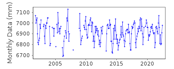
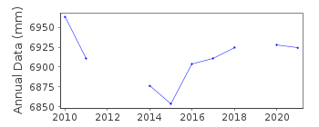
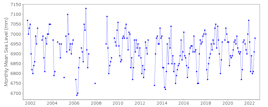
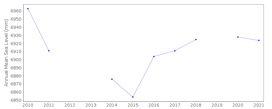
Tide Gauge Data
Additional Data Sources (guide to additional data sources)
Nearby GNSS Stations from SONEL: NAINNearby Real Time Stations from VLIZ: nain
Fast Delivery Data from UHSLC station 833: hourly and daily
Research Quality Data from UHSLC station 833: hourly and daily
Station Documentation
Link to RLR information.Documentation added 1993-11-02
A discussion of Nain data 1964-72 including possible datum shift February 1967 is in Thompson et al., JGR 91(C12),14261-14268, 1986Documentation added 1994-03-23
Data up to 1988 revised, March 1994Documentation added 1994-07-15
Nain 970/134 RLR(1972) is 14.2m below BM YARDDocumentation added 1997-09-24
1963-88 gauge type=float/stilling well 1989-94 gauge= other pressure typeDocumentation added 2010-08-19
There is a gap in the dataset from 1988-2002. However, the RLR factor remains unchanged.Documentation added 2015-07-27
This year, rather than just sending the latest year of data, the complete dataset has been supplied. This has highlighted some differences in the data. From communications in the correspondence file for 2002 it appears that the Oceans and Fisheries meant to supply revised data for the stations supplied. This did not happen. The complete dataset includes these data revisions. Therefore, the whole dataset has now been re-entered.Documentation added 2015-07-30
Historic data was included in the above complete dataset. The datum for the period 1963-1988 is currently being queried. Until the Fisheries and Oceans Canada confirm the datum this data has been made Metric. Previously this station was flagged on review this station flag has now been removed.Documentation added 2017-06-29
Data for 2012-2015 updated for Canadian Atlantic network. The supplier provided a finalised version following a review by the regional office.Data Authority
Canadian Hydrographic Service615 Booth Street
Ottawa
Ontario K1A 0E6

![]()
![]()
![]()
