Data
- Obtaining
- Supplying
- High-Frequency
- Bottom Pressure Records
- Other Long Records
- GLOSS/ODINAFRICA Calibration Data
Donate
Donate to PSMSL
Data Notes
- Individual Station Data and Plot Notes
- Referencing the Data Set
- PSMSL Help File
- 2010 Changes to the PSMSL Data Files
Extracted from Database
03 Mar 2025
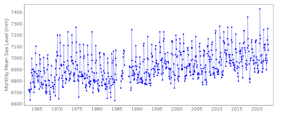
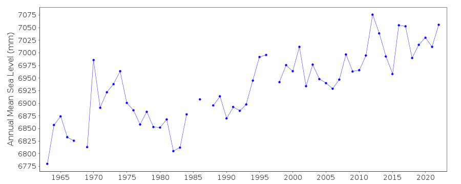
Station Information
| Station ID: | 1034 |
| Latitude: | 22.4425 |
| Longitude: | 114.183889 |
| Coastline code: | 611 |
| Station code: | 14 |
| Country: | HONG KONG |
| Time span of data: | 1963 – 2023 |
| Completeness (%): | 95 |
| Date of last update: | 11 Sep 2024 |
| Green Arrow: | Current Station |
| Yellow Marker: | Neighbouring RLR Station |
| Red Marker: | Neighbouring Metric Station |
Please note: In many cases, the station position in our database is accurate to only one minute. Thus, the tide gauge may not appear to be on the coast.
Tide Gauge Data
Station Documentation
Link to RLR information.Documentation added 2002-01-09
For an analysis of sea level changes in Hong Kong, see "Sea level changes in Hong Kong from tide gauge measurements" by X.Ding et al., Journal of Geodesy, 74, 683-689, 2001 and "Long-term sea-level changes in Hong Kong from tide-gauge records" by X.Ding et al., Journal of Coastal Research, 17, 749-754, 2001.Prior to 1986 the data was supplied by Port Works Division, Hong Kong
Documentation added 2010-07-12
When generating the RLR diagram from the new database the MSL for 2001 was calculated to be 1.492m rather than the previous 1.505m. However the value of the RLR factor and the relationship between RLR and the benchmark remain unchanged.Data Authority
Hong Kong Observatory134A Nathan Road
Kowloon
Documentation added 2000-06-08
The Hong Kong Observatory was formerly known as the Royal Observatory.

![]()
![]()
![]()
