Data
- Obtaining
- Supplying
- High-Frequency
- Bottom Pressure Records
- Other Long Records
- GLOSS/ODINAFRICA Calibration Data
Donate
Donate to PSMSL
Data Notes
- Individual Station Data and Plot Notes
- Referencing the Data Set
- PSMSL Help File
- 2010 Changes to the PSMSL Data Files
Extracted from Database
11 May 2026
WARNING: QCFLAG EXISTS. PLEASE READ THE DOCUMENTATION.
Station Information
| Station ID: | 1060 |
| Latitude: | 34.067222 |
| Longitude: | 139.480833 |
| Coastline code: | 642 |
| Station code: | 98 |
| Country: | JAPAN |
| Time span of data: | 1964 – 2022 |
| Completeness (%): | 98 |
| Date of last update: | 03 Feb 2023 |
| Green Arrow: | Current Station |
| Yellow Marker: | Neighbouring RLR Station |
| Red Marker: | Neighbouring Metric Station |
Please note: In many cases, the station position in our database is accurate to only one minute. Thus, the tide gauge may not appear to be on the coast.
Tide Gauge Data
Additional Data Sources (guide to additional data sources)
Research Quality Data from UHSLC station 357: hourly and dailyStation Documentation
Link to RLR information.Documentation added 1993-07-12
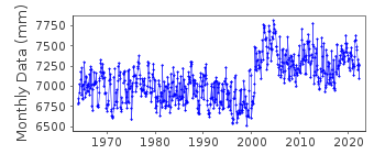
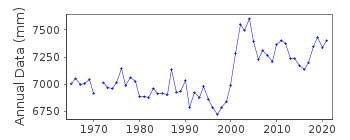
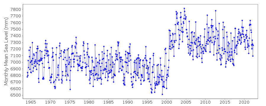
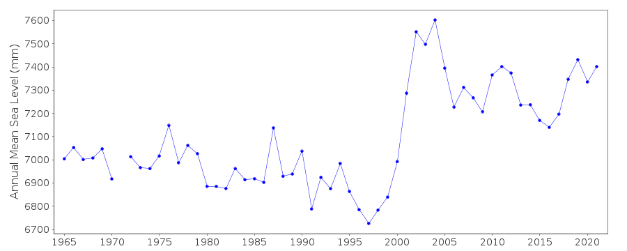
Miyake Sima 642/098 RLR(1969) is 9.7m below BM Miyake SimaDocumentation added 2002-10-22
Data for 1996-2001 received from University of Hawaii. The elevated mean levels of 9/2000-12/2001 are due to island sinking as a result of the volcanic eruption of Oyama during 6-8/2000.Documentation added 2008-03-06
Data 2001 onwards flagged as there appears to a sudden rise in the dataset.Documentation added 2012-02-21
A massive earthquake magnitude 9.0 occurred at 14.46 JST (05.46 UTC) on Friday 11th March 2011 with the epicentre approx. 70km east of the Oshika Peninsula of Tohoku. It was the most powerful known earthquake to hit Japan triggering a tsunami with waves up to 40.5m and travelling up to 10km inland.Documentation added 2016-03-15
The apparent datum shift occuring during 2000 has been investigated. What was originally thought of as a datum error is now recognised as a real event. On July 14th 2000 Mount Oyama on the island began a series of eruptions. By September of that year the island had been completely evacuated. After a 4 year period of volcanic emissions residents were allowed to return permanently in February 2005. Because this was a real event the data point flags have been removed. However, the station flag remains.Data Authority
Japan Oceanographic Data CentreHydrographic Department, Maritime Safety Agency
MLIT Aomi Building
2-5-18, Aomi, Koto-ku
Tokyo 135-0064

![]()
![]()
![]()
