Data
- Obtaining
- Supplying
- High-Frequency
- Bottom Pressure Records
- Other Long Records
- GLOSS/ODINAFRICA Calibration Data
Donate
Donate to PSMSL
Data Notes
- Individual Station Data and Plot Notes
- Referencing the Data Set
- PSMSL Help File
- 2010 Changes to the PSMSL Data Files
Extracted from Database
03 Mar 2025
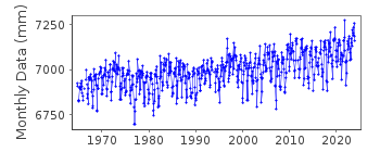
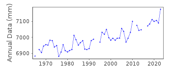
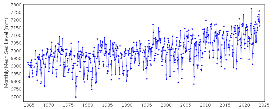
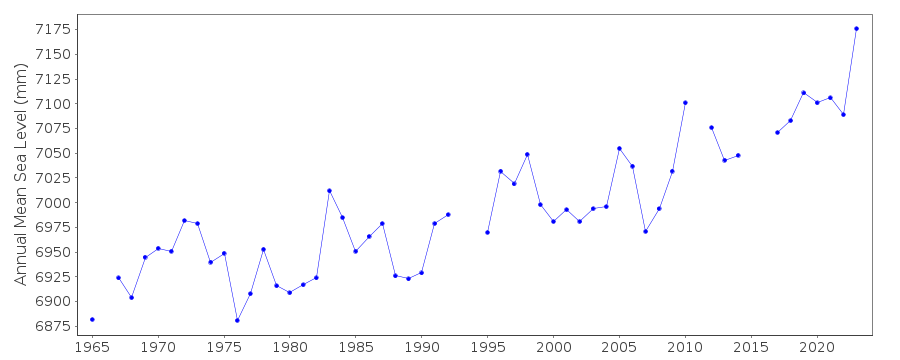
Station Information
| Station ID: | 1068 |
| Latitude: | 41.173333 |
| Longitude: | -73.181667 |
| Coastline code: | 960 |
| Station code: | 147 |
| Country: | UNITED STATES |
| Time span of data: | 1964 – 2024 |
| Completeness (%): | 96 |
| Date of last update: | 23 Jan 2025 |
| Green Arrow: | Current Station |
| Yellow Marker: | Neighbouring RLR Station |
| Red Marker: | Neighbouring Metric Station |
Please note: In many cases, the station position in our database is accurate to only one minute. Thus, the tide gauge may not appear to be on the coast.
Tide Gauge Data
Additional Data Sources (guide to additional data sources)
Nearby Real Time Stations from VLIZ: bgct, bgct2Station Documentation
Link to RLR information.Documentation added 1991-06-11
Bridgeport 960/147 RLR(1972) is 9.9m below BM15Documentation added 2011-08-11
Using NOAA data the RLR diagram wa re-drawn. Primary benchmark is now 7150 A 1987 3.544m above gauge datum. Previous PSMSL benchmark BM 15 relates to NO 15 1964 in the NOAA report value 4.624m above gauge datum during Epoch 1960-1978. No value is given for this benchmark in Epoch 1983-2001.Data Authority
N.O.A.A. / N.O.S.N/oes33, Ssmc4, Room 6531
1305 East-West Highway
Silver Spring,
MD 20910

![]()
![]()
![]()
