Data
- Obtaining
- Supplying
- High-Frequency
- Bottom Pressure Records
- Other Long Records
- GLOSS/ODINAFRICA Calibration Data
Donate
Donate to PSMSL
Data Notes
- Individual Station Data and Plot Notes
- Referencing the Data Set
- PSMSL Help File
- 2010 Changes to the PSMSL Data Files
Extracted from Database
06 Apr 2026
Station Information
| Station ID: | 1106 |
| Latitude: | 26.646667 |
| Longitude: | -81.87 |
| Coastline code: | 940 |
| Station code: | 65 |
| Country: | UNITED STATES |
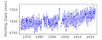
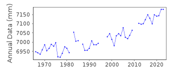
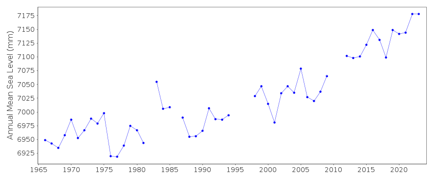
| Time span of data: | 1965 – 2025 |
| Completeness (%): | 93 |
| Date of last update: | 28 Jan 2026 |
| Green Arrow: | Current Station |
| Yellow Marker: | Neighbouring RLR Station |
| Red Marker: | Neighbouring Metric Station |
Please note: In many cases, the station position in our database is accurate to only one minute. Thus, the tide gauge may not appear to be on the coast.
Tide Gauge Data
Additional Data Sources (guide to additional data sources)
Nearby GNSS Stations from SONEL: FMYRNearby Real Time Stations from VLIZ: fmfl, fmfl2
Station Documentation
Link to RLR information.Documentation added 1991-06-11
Fort Myers 940/065 RLR(1973) is 8.3m below BM 6Documentation added 1993-07-29
Many stations on the Gulf coast have large values for September 1961.Documentation added 2011-11-24
Using information from the NOAA website the RLR diagram has been revised. Previous Primary benchmark BM 6 no longer appears in the NOAA reports. Benchmark 5520 C 1978 which appears in the original RLR diagram is included in the NOAA 1987 report with the same value of 2.755m but does not feature in the 2003 report. Current Primary benchmark appears in both reports 5520 A 1978 with the same value of 2.746m relative to gauge datum.Data Authority
N.O.A.A. / N.O.S.N/oes33, Ssmc4, Room 6531
1305 East-West Highway
Silver Spring,
MD 20910

![]()
![]()
![]()
