Data
- Obtaining
- Supplying
- High-Frequency
- Bottom Pressure Records
- Other Long Records
- GLOSS/ODINAFRICA Calibration Data
Donate
Donate to PSMSL
Data Notes
- Individual Station Data and Plot Notes
- Referencing the Data Set
- PSMSL Help File
- 2010 Changes to the PSMSL Data Files
Extracted from Database
03 Mar 2025
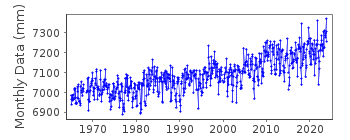
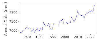
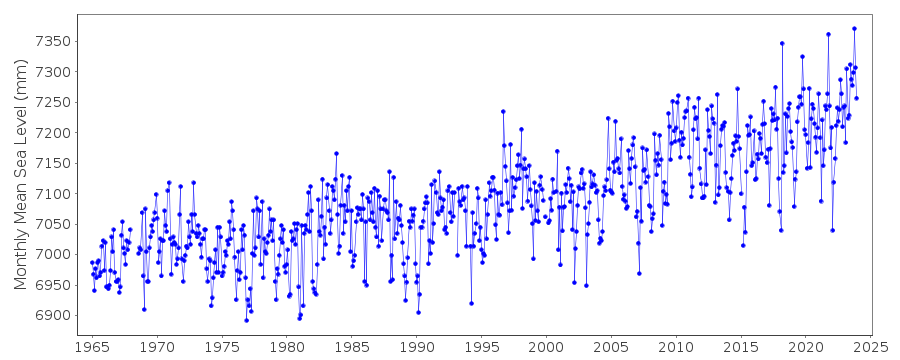
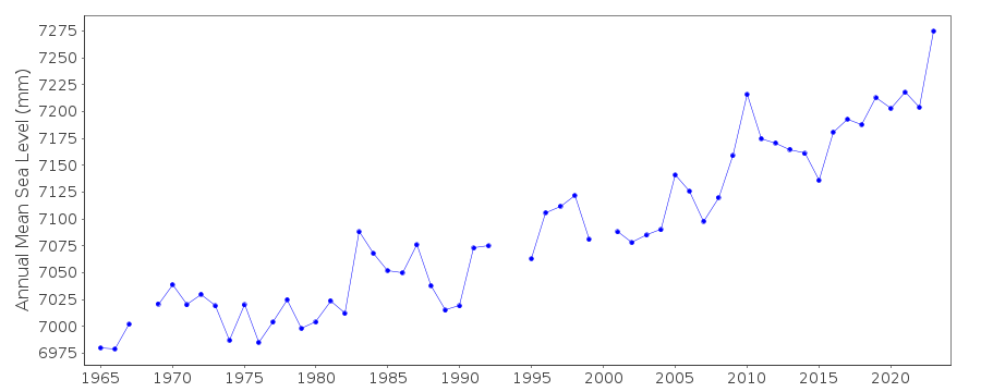
Station Information
| Station ID: | 1111 |
| Latitude: | 41.285 |
| Longitude: | -70.096667 |
| Coastline code: | 960 |
| Station code: | 166 |
| Country: | UNITED STATES |
| Time span of data: | 1965 – 2024 |
| Completeness (%): | 98 |
| Date of last update: | 23 Jan 2025 |
| Green Arrow: | Current Station |
| Yellow Marker: | Neighbouring RLR Station |
| Red Marker: | Neighbouring Metric Station |
Please note: In many cases, the station position in our database is accurate to only one minute. Thus, the tide gauge may not appear to be on the coast.
Tide Gauge Data
Additional Data Sources (guide to additional data sources)
Research Quality Data from UHSLC station 743: hourly and dailyStation Documentation
Link to RLR information.Documentation added 1991-06-11
Nantucket 960/166 RLR(1973) is 9.3m below BM22Documentation added 2011-08-17
Using NOAA data the RLR diagram has been revised. Primary benchmark is now NO 25 1968 3.157m above TGZ in Epoch 1960-1978 and 3.147m above TGZ in Epoch 1983-2001. Previous benchmark BM 22 still exists and remains 3.685m above gauge datum. This has now been given the official name NO 22 1934. The station name has been changed from Nantucket to Nantucket Island to agree with the NOAA website.Data Authority
N.O.A.A. / N.O.S.N/oes33, Ssmc4, Room 6531
1305 East-West Highway
Silver Spring,
MD 20910

![]()
![]()
![]()
