Data
- Obtaining
- Supplying
- High-Frequency
- Bottom Pressure Records
- Other Long Records
- GLOSS/ODINAFRICA Calibration Data
Donate
Donate to PSMSL
Data Notes
- Individual Station Data and Plot Notes
- Referencing the Data Set
- PSMSL Help File
- 2010 Changes to the PSMSL Data Files
Extracted from Database
13 Jul 2026
Station Information
| Station ID: | 1182 |
| Latitude: | 29.146667 |
| Longitude: | -80.963333 |
| Coastline code: | 960 |
| Station code: | 7 |
| Country: | UNITED STATES |
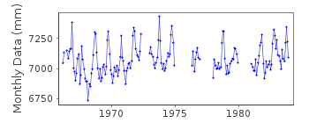
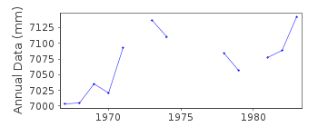
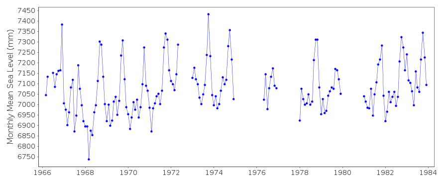
| Time span of data: | 1966 – 1983 |
| Completeness (%): | 76 |
| Date of last update: | 05 Oct 1987 |
| Green Arrow: | Current Station |
| Yellow Marker: | Neighbouring RLR Station |
| Red Marker: | Neighbouring Metric Station |
Please note: In many cases, the station position in our database is accurate to only one minute. Thus, the tide gauge may not appear to be on the coast.
Tide Gauge Data
Station Documentation
Link to RLR information.Documentation added 1991-06-11
Daytona Beach Shores960/007 RLR(1970) is 11.7m below BM1(1966)Documentation added 1993-07-12
Daytona Beach Shores960/007 RLR(1970) is 11.7m below BM1(1966)Documentation added 2012-02-23
This is now an Historic station.Last data received was for 1983. Primarybenchmark on the NOAA website is still listed as on the original diagram NO 1
1966. However, the datum relationship on the original diagram is 5.907m
(19.38ft) when calculated from the NOAA station sheets it is 5.599m. The NOAA
figure has been used for the updated diagram.
Data Authority
N.O.A.A. / N.O.S.N/oes33, Ssmc4, Room 6531
1305 East-West Highway
Silver Spring,
MD 20910

![]()
![]()
![]()
