Data
- Obtaining
- Supplying
- High-Frequency
- Bottom Pressure Records
- Other Long Records
- GLOSS/ODINAFRICA Calibration Data
Donate
Donate to PSMSL
Data Notes
- Individual Station Data and Plot Notes
- Referencing the Data Set
- PSMSL Help File
- 2010 Changes to the PSMSL Data Files
Extracted from Database
03 Mar 2025
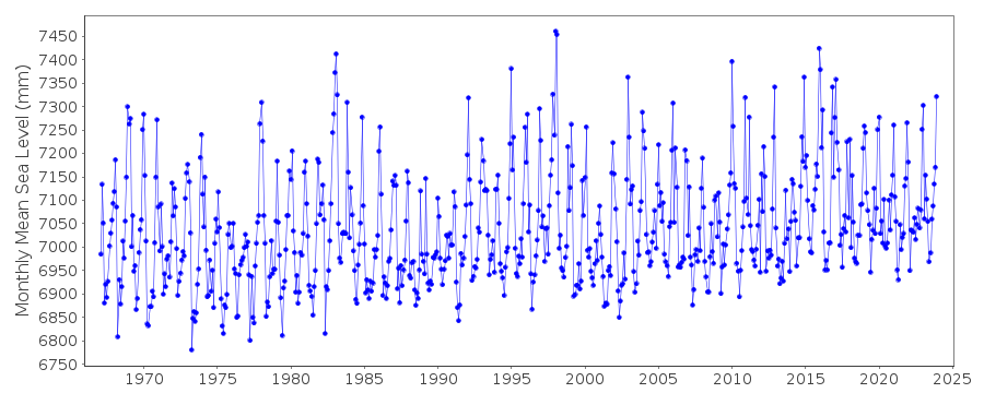
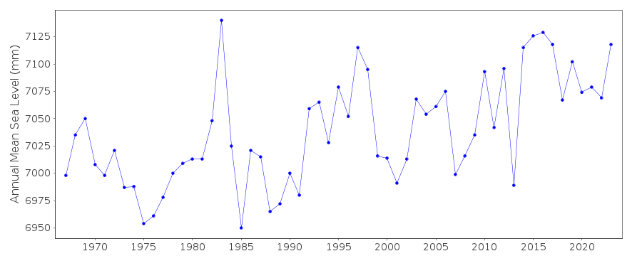
Station Information
| Station ID: | 1196 |
| Latitude: | 44.625 |
| Longitude: | -124.041667 |
| GLOSS ID: | 157 |
| Coastline code: | 823 |
| Station code: | 16 |
| Country: | UNITED STATES |
| Time span of data: | 1967 – 2024 |
| Completeness (%): | 100 |
| Date of last update: | 23 Jan 2025 |
| Green Arrow: | Current Station |
| Yellow Marker: | Neighbouring RLR Station |
| Red Marker: | Neighbouring Metric Station |
Please note: In many cases, the station position in our database is accurate to only one minute. Thus, the tide gauge may not appear to be on the coast.
Tide Gauge Data
Additional Data Sources (guide to additional data sources)
Nearby GNSS Stations from SONEL: P367, NEWP, ORSBNearby Real Time Stations from VLIZ: sbea2, sbea
Fast Delivery Data from UHSLC station 592: hourly and daily
Research Quality Data from UHSLC station 592: hourly and daily
Station Documentation
Link to RLR information.Documentation added 1991-06-11
South Beach 823/016 RLR(1974) is 10.7m below BMA590Documentation added 2011-12-20
Using NOAA data the RLR diagram has been revised. Former Primary benchmark A 590 1965 6.419m above gauge datum appears in the NOAA report dated 1988 but not in the report of 2003. Current Primary benchmark is C 590 1965 6.194m above gauge datum.Documentation added 2017-02-07
The whole dataset for South Beach has been revised by NOAA. The complete dataset which includes additional data has been loaded onto the database.Data Authority
N.O.A.A. / N.O.S.N/oes33, Ssmc4, Room 6531
1305 East-West Highway
Silver Spring,
MD 20910

![]()
![]()
![]()
