Data
- Obtaining
- Supplying
- High-Frequency
- Bottom Pressure Records
- Other Long Records
- GLOSS/ODINAFRICA Calibration Data
Donate
Donate to PSMSL
Data Notes
- Individual Station Data and Plot Notes
- Referencing the Data Set
- PSMSL Help File
- 2010 Changes to the PSMSL Data Files
Extracted from Database
03 Mar 2025
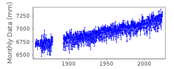
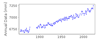
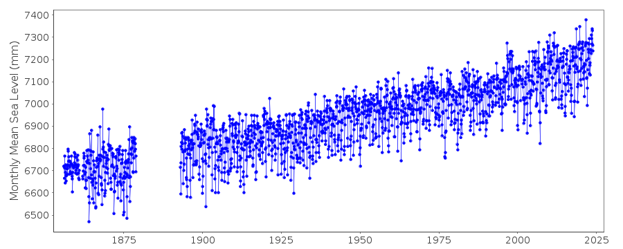
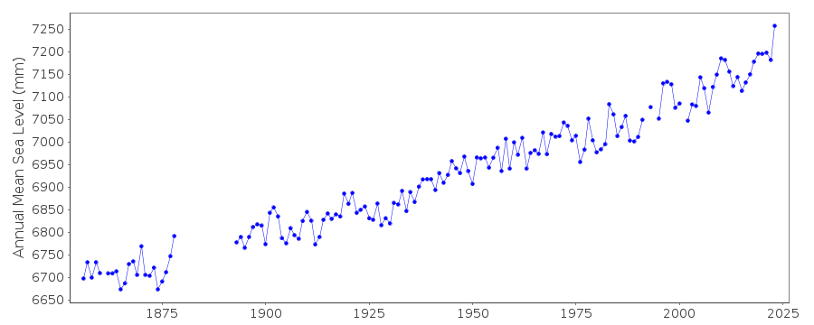
Station Information
| Station ID: | 12 |
| Latitude: | 40.7 |
| Longitude: | -74.013333 |
| Coastline code: | 960 |
| Station code: | 121 |
| Country: | UNITED STATES |
| Time span of data: | 1856 – 2024 |
| Completeness (%): | 91 |
| Date of last update: | 07 Jan 2025 |
| Green Arrow: | Current Station |
| Yellow Marker: | Neighbouring RLR Station |
| Red Marker: | Neighbouring Metric Station |
Please note: In many cases, the station position in our database is accurate to only one minute. Thus, the tide gauge may not appear to be on the coast.
Tide Gauge Data
Additional Data Sources (guide to additional data sources)
Nearby GNSS Stations from SONEL: NYBR, NYBPNearby Real Time Stations from VLIZ: btny2, btny
Research Quality Data from UHSLC station 745: hourly and daily
Station Documentation
Link to RLR information.Documentation - date unknown
DATA 1922-1926 INTERPOLATED FROM HALF-TIDE LEVELSDocumentation added 1991-06-11
New York 960/121 RLR(1964) is 12.0m above BM748Documentation added 2011-08-11
Using data extracted from the NOAA website the RLR diagram has been re-drawn.Primary benchmark now appears to be NO 7 1975 5.470m above TGZ. The benchmark previously used by PSMSL was BM748 6.724m above TGZ. In the NOAA benchmark report this is listed as 'BM' upon further investigation this relates to 851 8750 TIDAL 748 with a value of 6.722m from Epoch 1983-2001.Title of the Station was updated to New York (The Battery) to agree with the NOAA website.
Data Authority
N.O.A.A. / N.O.S.N/oes33, Ssmc4, Room 6531
1305 East-West Highway
Silver Spring,
MD 20910

![]()
![]()
![]()
