Data
- Obtaining
- Supplying
- High-Frequency
- Bottom Pressure Records
- Other Long Records
- GLOSS/ODINAFRICA Calibration Data
Donate
Donate to PSMSL
Data Notes
- Individual Station Data and Plot Notes
- Referencing the Data Set
- PSMSL Help File
- 2010 Changes to the PSMSL Data Files
Extracted from Database
03 Mar 2025
Station Information
| Station ID: | 1215 |
| Latitude: | 54.842556 |
| Longitude: | -5.120028 |
| Coastline code: | 170 |
| Station code: | 236 |
| Country: | UNITED KINGDOM |
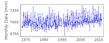
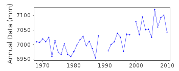
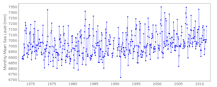
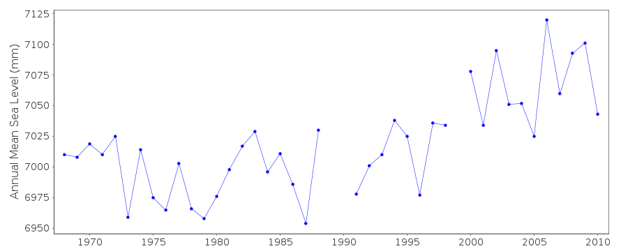
| Time span of data: | 1968 – 2011 |
| Completeness (%): | 96 |
| Date of last update: | 02 Jul 2012 |
| Green Arrow: | Current Station |
| Yellow Marker: | Neighbouring RLR Station |
| Red Marker: | Neighbouring Metric Station |
Please note: In many cases, the station position in our database is accurate to only one minute. Thus, the tide gauge may not appear to be on the coast.
Tide Gauge Data
Additional Data Sources (guide to additional data sources)
Nearby GNSS Stations from SONEL: PORKNearby Real Time Stations from VLIZ: porp
Station Documentation
Link to RLR information.Documentation added 1991-06-11
Portpatrick 170/236 RLR(1980) is 11.7m below TGBM NW9976 5421Documentation added 1993-07-12
Portpatrick 170/236 RLR(1980) is 11.7m below TGBM NW9976 5421Documentation added 1994-07-20
Gauge was a Lea stilling well from November 1964 until 1989. InJuly 1990 an "A Class" bubbler was installed.
Documentation added 1997-04-10
RLR(1995) determined to replace RLR(1980)Documentation added 2001-01-02
Recent work on vertical land movements in the UK can be found fromthe University of Nottingham web site:
http://ukcogr.iessg.nottingham.ac.uk/~eosi/
Documentation added 2013-05-09
There are no MSL's for 2012. This is because the primary channel is recording over 1m high because the stilling well opening is buried in silt.Documentation added 2014-07-04
There again no MSL's values for Portpatrick 2013. The primary channel, the float gauge is still recording over 1m high. There is also an issue with power to the gauge, when the float gauge loses power it also loses calibration. TGI visited the site 27.02.2013 to carry out general maintenance and change the compressor. The issues with the gauge will be investigated during the next general maintenance visit.Data Authority
Environment AgencyHorizon House
Deanery Road
BS1 5AH
Bristol

![]()
![]()
![]()
