Data
- Obtaining
- Supplying
- High-Frequency
- Bottom Pressure Records
- Other Long Records
- GLOSS/ODINAFRICA Calibration Data
Donate
Donate to PSMSL
Data Notes
- Individual Station Data and Plot Notes
- Referencing the Data Set
- PSMSL Help File
- 2010 Changes to the PSMSL Data Files
Extracted from Database
03 Mar 2025
Station Information
| Station ID: | 1238 |
| Latitude: | 40.844139 |
| Longitude: | 25.878272 |
| Coastline code: | 290 |
| Station code: | 65 |
| Country: | GREECE |
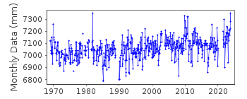
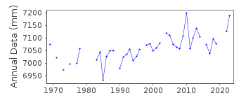
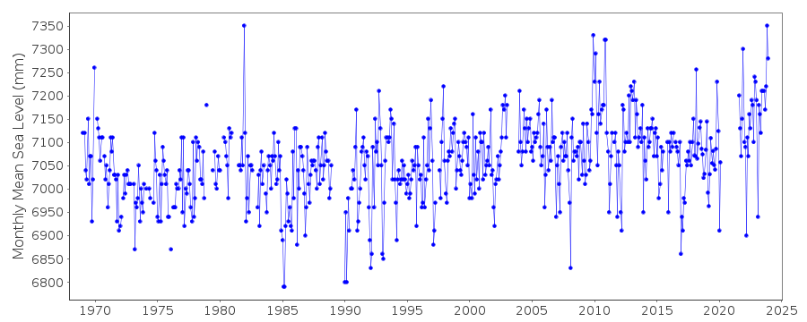
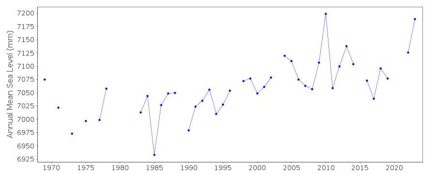
| Time span of data: | 1969 – 2023 |
| Completeness (%): | 87 |
| Date of last update: | 20 Feb 2024 |
| Green Arrow: | Current Station |
| Yellow Marker: | Neighbouring RLR Station |
| Red Marker: | Neighbouring Metric Station |
Please note: In many cases, the station position in our database is accurate to only one minute. Thus, the tide gauge may not appear to be on the coast.
Tide Gauge Data
Station Documentation
Link to RLR information.Documentation - date unknown
1969-1980 Data from readings of tide poleDocumentation added 1991-06-11
Alexandroupolis 290/065 RLR(1977) is 9.1m below BM R29Documentation added 1993-07-12
Alexandroupolis 290/065 RLR(1977) is 9.1m below BM R29Documentation added 1997-03-11
The contributing authority advises that anomalous valuesare the result of met. influences
Documentation added 2013-06-26
The RLR diagram has temporarily been taken off line while a benchmark query is pursued.Documentation added 2013-07-11
Following the receipt of new datum diagrams from the Hellenic Navy the RLR factor for the historic data up to 2001 has been revised. As this solves the datum problem the RLR diagram has been switched online again.Data Authority
Hellenic Navy Hydrographic ServiceGeographic Policy and International Relations Office
TGN 1040
Athens

![]()
![]()
![]()
