Data
- Obtaining
- Supplying
- High-Frequency
- Bottom Pressure Records
- Other Long Records
- GLOSS/ODINAFRICA Calibration Data
Donate
Donate to PSMSL
Data Notes
- Individual Station Data and Plot Notes
- Referencing the Data Set
- PSMSL Help File
- 2010 Changes to the PSMSL Data Files
Extracted from Database
21 Apr 2025
Station Information
| Station ID: | 1241 |
| Latitude: | 64.859456 |
| Longitude: | 11.230107 |
| GLOSS ID: | 234 |
| Coastline code: | 40 |
| Station code: | 136 |
| Country: | NORWAY |
| Time span of data: | 1969 – 2024 |
| Completeness (%): | 98 |
| Date of last update: | 09 Jan 2025 |
| Green Arrow: | Current Station |
| Yellow Marker: | Neighbouring RLR Station |
| Red Marker: | Neighbouring Metric Station |
Please note: In many cases, the station position in our database is accurate to only one minute. Thus, the tide gauge may not appear to be on the coast.
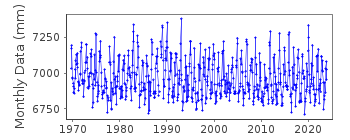
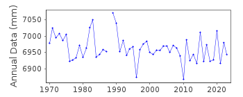
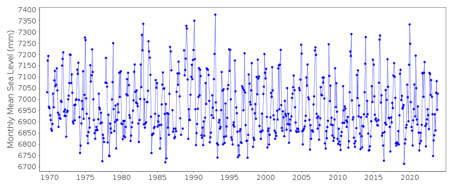
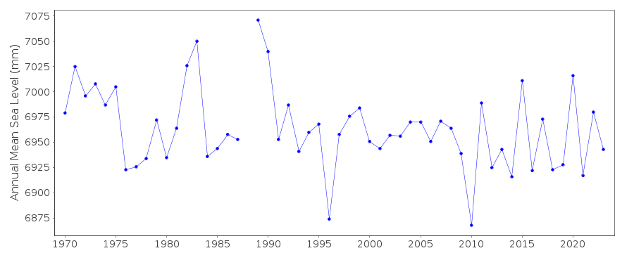
Tide Gauge Data
Additional Data Sources (guide to additional data sources)
Nearby GNSS Stations from SONEL: VIKCNearby Real Time Stations from VLIZ: rorv
Fast Delivery Data from UHSLC station 803: hourly and daily
Research Quality Data from UHSLC station 803: hourly and daily
Station Documentation
Link to RLR information.Documentation added 1991-06-11
Rorvik 040/136 RLR(1972) is 9.2m below BM FM5Documentation added 1995-03-30
tide gauge network modernised, new equipment installed in 1988Documentation added 2010-07-19
The Norwegian Mapping Authority has revised the complete dataset for Rorvik.Primary bench mark is now H20 N61 7.077m above TGZ (see copy of the attached to the new RLR diagram). RLR for the station has been re-calculated using 2008 as the RLR year. New RLRfactor is 5.723m while RLR (2008) is 12.8m below TGBM H20 N61.
Documentation added 2012-09-05
For information on sea level change along the Norwegian coast see paper "Contributions to sea level variability along the Norwegian coast for 1960-2010" by K.Richter, J.E.O. Nilsen and H Drange.Documentation added 2018-01-30
Using updated values supplied by the Norwegian Mapping Authority Data value for July 1988 has been removed and that for November 1988 revised.Data Authority
Norwegian Mapping AuthorityHydrographic Service
Po. Box 60
4001 Stavanger

![]()
![]()
![]()
