Data
- Obtaining
- Supplying
- High-Frequency
- Bottom Pressure Records
- Other Long Records
- GLOSS/ODINAFRICA Calibration Data
Donate
Donate to PSMSL
Data Notes
- Individual Station Data and Plot Notes
- Referencing the Data Set
- PSMSL Help File
- 2010 Changes to the PSMSL Data Files
Extracted from Database
21 Apr 2025
Station Information
| Station ID: | 1252 |
| Latitude: | 7.333333 |
| Longitude: | 134.466667 |
| GLOSS ID: | 120 |
| Coastline code: | 711 |
| Station code: | 21 |
| Country: | PALAU |
| Time span of data: | 1969 – 2018 |
| Completeness (%): | 96 |
| Date of last update: | 28 Jan 2020 |
| Green Arrow: | Current Station |
| Yellow Marker: | Neighbouring RLR Station |
| Red Marker: | Neighbouring Metric Station |
Please note: In many cases, the station position in our database is accurate to only one minute. Thus, the tide gauge may not appear to be on the coast.
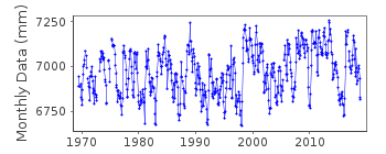
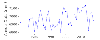
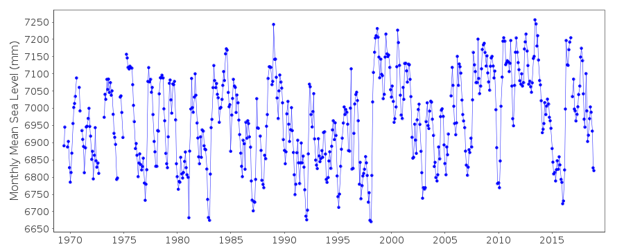
Tide Gauge Data
Additional Data Sources (guide to additional data sources)
Nearby GNSS Stations from SONEL: PALR, PALANearby Real Time Stations from VLIZ: mala
Fast Delivery Data from UHSLC station 7: hourly and daily
Research Quality Data from UHSLC station 7: hourly and daily
Station Documentation
Link to RLR information.Documentation added 1995-04-26
station recoded from 710/021 to 711/021 on 26th April 1995Documentation added 1995-07-31
Malakal 711/021 RLR(1983) is 9.3m below BM2Documentation added 1996-10-07
gauge type: unconfirmed (1969-70)Bristol bubbler (1971-7/1974)Fischer and Porter Analog-to-Digital Recorder (ADR) (8/1974-)Handar Encoder (ENC), (1990-) (*used as primary gauge beginning May 1991)Documentation added 1997-11-13
data 1969-70 contributed by authority code 85Documentation added 2010-11-17
Complete dataset 1969 - 2009 supplied by UHSLC. After checking these with existing data values these data have been loaded onto the database.RLR remains 5.424m.Documentation added 2013-10-14
Complete dataset May 1969 to April 2012 loaded onto the database from UHSLCDocumentation added 2015-10-29
Complete updated JASL data through to 2014 added to the database. From the UHSLC levelling sheet from 2005 Primary Benchmark is now UH 4 6.834m above datum. This has been added to the RLR diagram. The previous Primary benchmark BM 2 was destroyed in the early 1990's.Data Authority
University of Hawaii Sea Level CenterDepartment of Oceanography Division of Natural Sciences
1000 Pope Road
Honolulu
Hawaii 96822

![]()
![]()
![]()
