Data
- Obtaining
- Supplying
- High-Frequency
- Bottom Pressure Records
- Other Long Records
- GLOSS/ODINAFRICA Calibration Data
Donate
Donate to PSMSL
Data Notes
- Individual Station Data and Plot Notes
- Referencing the Data Set
- PSMSL Help File
- 2010 Changes to the PSMSL Data Files
Extracted from Database
03 Mar 2025
WARNING: QCFLAG EXISTS. PLEASE READ THE DOCUMENTATION.
Station Information
| Station ID: | 1274 |
| Latitude: | -12.05 |
| Longitude: | -77.15 |
| GLOSS ID: | 173 |
| Coastline code: | 848 |
| Station code: | 32 |
| Country: | PERU |
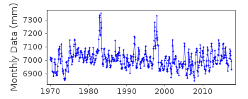
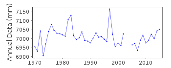
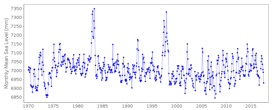
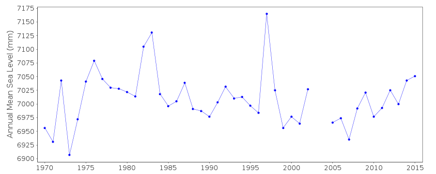
| Time span of data: | 1970 – 2017 |
| Completeness (%): | 98 |
| Date of last update: | 28 Jan 2020 |
| Green Arrow: | Current Station |
| Yellow Marker: | Neighbouring RLR Station |
| Red Marker: | Neighbouring Metric Station |
Please note: In many cases, the station position in our database is accurate to only one minute. Thus, the tide gauge may not appear to be on the coast.
Tide Gauge Data
Additional Data Sources (guide to additional data sources)
Nearby GNSS Stations from SONEL: CALLNearby Real Time Stations from VLIZ: call
Fast Delivery Data from UHSLC station 93: hourly and daily
Research Quality Data from UHSLC station 93: hourly and daily
Station Documentation
Link to RLR information.Documentation - date unknown
Taken as a continuous record by TOGA sea level center but many ad-hoc datum corrections made to the original data.Documentation added 1991-10-16
Original data adjusted by TOGADocumentation added 1993-03-22
Data received from TOGA officeDocumentation added 1994-05-13
Earthquake 3/10/1974Documentation added 2012-01-18
Using data from the latest UHSLC JASL cd the 'METRIC' dataset has been updated. Data values for 2002-2010 have been added to the dataset.Documentation added 2013-10-15
Complete UHSLC dataset 1970-2012 loaded as additional data values had been addedDocumentation added 2015-10-20
Using information from the UHSLC levelling sheets Callao 2 has been made RLR from October 2011 onwards.Documentation added 2015-10-29
Complete updated JASL data through to 2014 reloaded onto the database.Data Authority
University of Hawaii Sea Level CenterDepartment of Oceanography Division of Natural Sciences
1000 Pope Road
Honolulu
Hawaii 96822

![]()
![]()
![]()
