Data
- Obtaining
- Supplying
- High-Frequency
- Bottom Pressure Records
- Other Long Records
- GLOSS/ODINAFRICA Calibration Data
Donate
Donate to PSMSL
Data Notes
- Individual Station Data and Plot Notes
- Referencing the Data Set
- PSMSL Help File
- 2010 Changes to the PSMSL Data Files
Extracted from Database
03 Mar 2025
Station Information
| Station ID: | 1357 |
| Latitude: | 28.966667 |
| Longitude: | -113.55 |
| Coastline code: | 830 |
| Station code: | 25 |
| Country: | MEXICO |
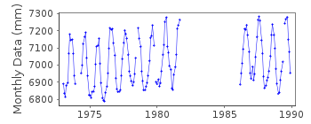
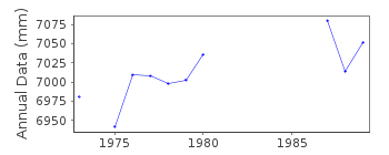
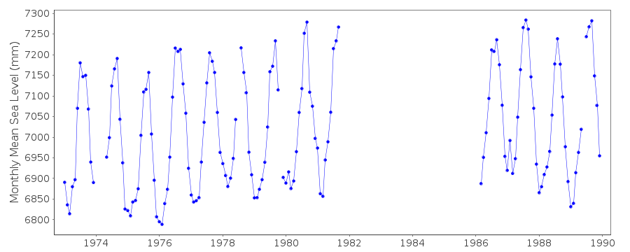
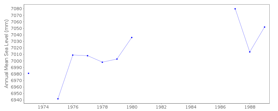
| Time span of RLR data: | 1973 – 1989 |
| RLR completeness (%): | 71 |
| Time span of metric data: | 1973 – 1994 |
| Metric completeness (%): | 70 |
| Date of last update: | 03 Dec 1997 |
| Green Arrow: | Current Station |
| Yellow Marker: | Neighbouring RLR Station |
| Red Marker: | Neighbouring Metric Station |
Please note: In many cases, the station position in our database is accurate to only one minute. Thus, the tide gauge may not appear to be on the coast.
Tide Gauge Data
Additional Data Sources (guide to additional data sources)
Nearby GNSS Stations from SONEL: TNBAResearch Quality Data from UHSLC station 310: hourly and daily
Station Documentation
Link to RLR information.Documentation added 1991-06-11
Bahia De Los Angeles830/025 RLR(1980) is 8.4m below BM1Documentation added 1997-01-30
Large earthquake offshore of Mexico about 19 degrees North on 9 October 1995 with large tsunami generated. See article by A.E.Filonov in EOS, 78(3), 1997.Documentation added 1997-11-14
data 1990-94 received from the University of Hawaii Sea Level Center Instrument type: standard gauge (1973-1982) float and well Leupold Stevens (LS) 7001 (1983-)This is now an historic station last data 1989Data Authority
C.I.C.E.S.E.P.O. Box 434844
San Diego
CA 92143-4844

![]()
![]()
![]()
