Data
- Obtaining
- Supplying
- High-Frequency
- Bottom Pressure Records
- Other Long Records
- GLOSS/ODINAFRICA Calibration Data
Donate
Donate to PSMSL
Data Notes
- Individual Station Data and Plot Notes
- Referencing the Data Set
- PSMSL Help File
- 2010 Changes to the PSMSL Data Files
Extracted from Database
21 Apr 2025
Station Information
| Station ID: | 1393 |
| Latitude: | 18.335 |
| Longitude: | -64.92 |
| Coastline code: | 939 |
| Station code: | 1 |
| Country: | VIRGIN ISLANDS, U.S. |
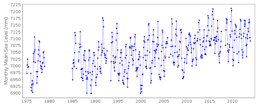
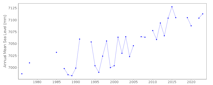
| Time span of data: | 1975 – 2024 |
| Completeness (%): | 81 |
| Date of last update: | 23 Jan 2025 |
| Green Arrow: | Current Station |
| Yellow Marker: | Neighbouring RLR Station |
| Red Marker: | Neighbouring Metric Station |
Please note: In many cases, the station position in our database is accurate to only one minute. Thus, the tide gauge may not appear to be on the coast.
Tide Gauge Data
Additional Data Sources (guide to additional data sources)
Nearby GNSS Stations from SONEL: STVI, VITHNearby Real Time Stations from VLIZ: amal, amal2
Research Quality Data from UHSLC station 255: hourly and daily
Station Documentation
Link to RLR information.Documentation added 1993-07-08
Charlotte Amalie 939/001 RLR(1988) is 7.9m below BM 1975 # 1Documentation added 2011-12-20
Using NOAA data the RLR diagram has been revised. Previous Primary benchmark 1975 # 1 2.591m relative to gauge datum does not feature in the NOAA reports of 1989 and 2005. Primary benchmark is now 1639 F 1983 3.267m above gauge datum.Data Authority
N.O.A.A. / N.O.S.N/oes33, Ssmc4, Room 6531
1305 East-West Highway
Silver Spring,
MD 20910

![]()
![]()
![]()
