Data
- Obtaining
- Supplying
- High-Frequency
- Bottom Pressure Records
- Other Long Records
- GLOSS/ODINAFRICA Calibration Data
Donate
Donate to PSMSL
Data Notes
- Individual Station Data and Plot Notes
- Referencing the Data Set
- PSMSL Help File
- 2010 Changes to the PSMSL Data Files
Extracted from Database
03 Mar 2025
Station Information
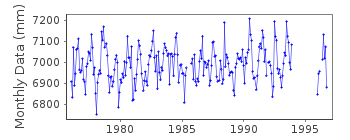
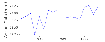
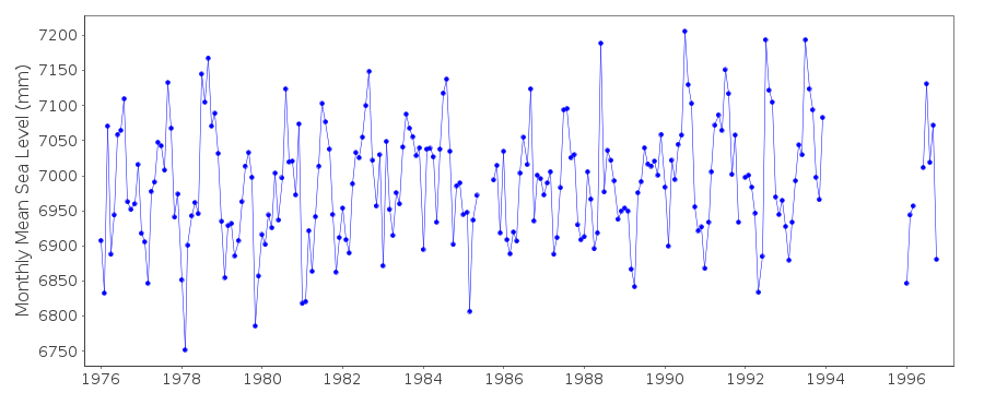
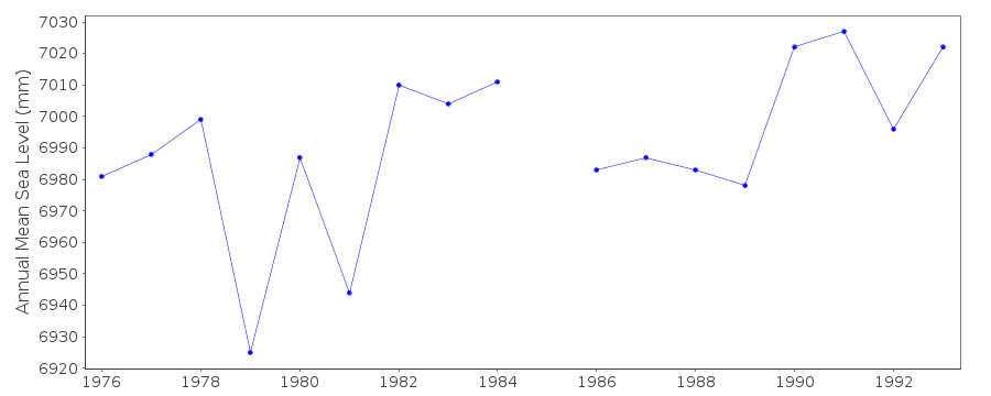
| Station ID: | 1426 |
| Latitude: | 19.266667 |
| Longitude: | -81.383333 |
| Coastline code: | 931 |
| Station code: | 11 |
| Country: | CAYMAN ISLANDS |
| Time span of data: | 1976 – 1996 |
| Completeness (%): | 87 |
| Date of last update: | 20 Aug 1997 |
| Green Arrow: | Current Station |
| Yellow Marker: | Neighbouring RLR Station |
| Red Marker: | Neighbouring Metric Station |
Please note: In many cases, the station position in our database is accurate to only one minute. Thus, the tide gauge may not appear to be on the coast.
Tide Gauge Data
Additional Data Sources (guide to additional data sources)
Nearby GNSS Stations from SONEL: GCGT, GCEAStation Documentation
Link to RLR information.Documentation added 1991-06-11
South Sound 931/011 RLR(1987) is 10.3m below BMGilberts StepDocumentation added 1993-07-12
South Sound 931/011 RLR(1987) is 10.3m below BMGilberts StepData Authority
Mosquito Research and Control UnitCayman Islands Government
P.O. Box 486
Grand Cayman
Cayman Islands

![]()
![]()
![]()
