Data
- Obtaining
- Supplying
- High-Frequency
- Bottom Pressure Records
- Other Long Records
- GLOSS/ODINAFRICA Calibration Data
Donate
Donate to PSMSL
Data Notes
- Individual Station Data and Plot Notes
- Referencing the Data Set
- PSMSL Help File
- 2010 Changes to the PSMSL Data Files
Extracted from Database
03 Mar 2025
Station Information
| Station ID: | 1456 |
| Latitude: | 37.95 |
| Longitude: | -8.883333 |
| Coastline code: | 210 |
| Station code: | 28 |
| Country: | PORTUGAL |
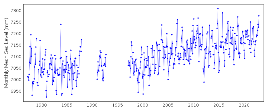
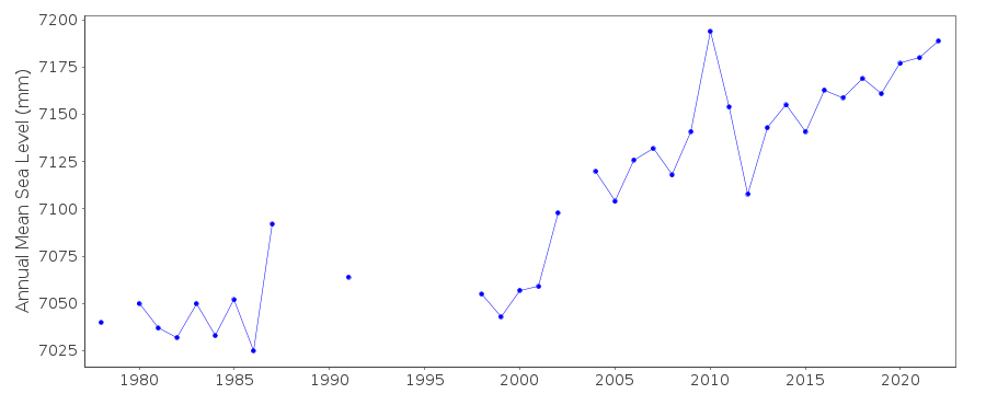
| Time span of data: | 1977 – 2022 |
| Completeness (%): | 82 |
| Date of last update: | 02 Mar 2023 |
| Green Arrow: | Current Station |
| Yellow Marker: | Neighbouring RLR Station |
| Red Marker: | Neighbouring Metric Station |
Please note: In many cases, the station position in our database is accurate to only one minute. Thus, the tide gauge may not appear to be on the coast.
Tide Gauge Data

Station Documentation
Link to RLR information.Documentation added 1991-06-11
Sines 210/028 RLR(1982) is 40.8m below TGBMDocumentation added 1993-07-12
Sines 210/028 RLR(1982) is 40.8m below TGBMDocumentation added 1998-11-04
data for 1985-86 replaced with revised values received from the Hydrographic Institute.Documentation added 2019-08-01
The complete dataset has been supplied by the Hydrographic Institute. The station has been reinstated.Data Authority
Hydrographic InstituteRua das Trinas 49
1249-093 Lisboa

![]()
![]()
![]()
