Data
- Obtaining
- Supplying
- High-Frequency
- Bottom Pressure Records
- Other Long Records
- GLOSS/ODINAFRICA Calibration Data
Donate
Donate to PSMSL
Data Notes
- Individual Station Data and Plot Notes
- Referencing the Data Set
- PSMSL Help File
- 2010 Changes to the PSMSL Data Files
Extracted from Database
13 Jul 2026
WARNING: QCFLAG EXISTS. PLEASE READ THE DOCUMENTATION.
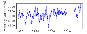
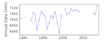
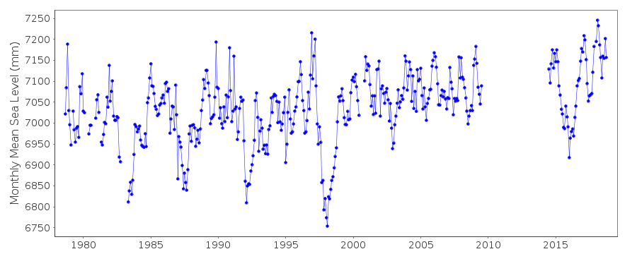
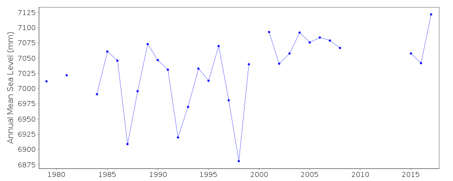
Station Information
| Station ID: | 1473 |
| Latitude: | 1.1 |
| Longitude: | 154.783333 |
| GLOSS ID: | 117 |
| Coastline code: | 710 |
| Station code: | 26 |
| Country: | MICRONESIA, FEDERATED STATES OF |
| Time span of data: | 1978 – 2018 |
| Completeness (%): | 82 |
| Date of last update: | 29 Jan 2020 |
| Green Arrow: | Current Station |
| Yellow Marker: | Neighbouring RLR Station |
| Red Marker: | Neighbouring Metric Station |
Please note: In many cases, the station position in our database is accurate to only one minute. Thus, the tide gauge may not appear to be on the coast.
Tide Gauge Data
Additional Data Sources (guide to additional data sources)
Nearby Real Time Stations from VLIZ: kapiFast Delivery Data from UHSLC station 29: hourly and daily
Research Quality Data from UHSLC station 29: hourly and daily
Station Documentation
Link to RLR information.Documentation added 1991-06-11
Kapingamarangi 710/026 RLR(1984) is 8.6m below BM#1Documentation added 1991-10-08
Daily and hourly residuals show significant fluctuations with duration of around a day associated with Westerley winds. Silting around the stilling well caused fluctuations in 1987-1989.Documentation added 1994-05-13
Silting around the stilling well caused questionable fluctuations 1987-90Documentation added 1996-10-08
Gauge type: Leupold and Stevens Analog-to-Digital Recorder (ADR);(Jul 1985-present) Handar Encoder (ENC)Documentation added 1998-12-31
Data for 1996 revised in December 1998Documentation added 2010-11-17
The complete dataset 1978-2008 has been supplied by UHSLC. After checking with existing data values these were loaded onto the database. Values for Nov 2000 onwards are 3-4mm lower than previous values. Previous data were flagged Jan 1987-Dec 1989 see above. The flags have been replaced with a station flag. RLR remains 6.037m.Documentation added 2015-10-28
Using the latest JASL data the complete dataset has been reloaded. Referring to the UH levelling information it is clear that the RLR diagram was prepared using the 1978 levelling value of 2.563m for benchmark UH-1.This remained stable within +2mm before being destroyed. The remaining stable benchmark in the 1996 and 2000 levelling is BM @ which relates to the tide staff. This has been added to the RLR diagram.Data Authority
University of Hawaii Sea Level CenterDepartment of Oceanography Division of Natural Sciences
1000 Pope Road
Honolulu
Hawaii 96822

![]()
![]()
![]()
