Data
- Obtaining
- Supplying
- High-Frequency
- Bottom Pressure Records
- Other Long Records
- GLOSS/ODINAFRICA Calibration Data
Donate
Donate to PSMSL
Data Notes
- Individual Station Data and Plot Notes
- Referencing the Data Set
- PSMSL Help File
- 2010 Changes to the PSMSL Data Files
Extracted from Database
01 Jun 2026
Station Information
| Station ID: | 157 |
| Latitude: | -34.6 |
| Longitude: | -58.366667 |
| Coastline code: | 860 |
| Station code: | 151 |
| Country: | ARGENTINA |
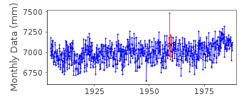
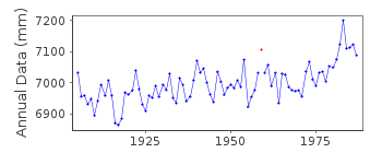
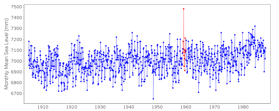
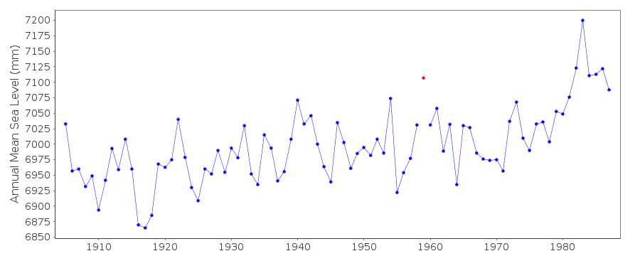
| Time span of data: | 1905 – 1987 |
| Completeness (%): | 100 |
| Date of last update: | 14 May 1991 |
| Green Arrow: | Current Station |
| Yellow Marker: | Neighbouring RLR Station |
| Red Marker: | Neighbouring Metric Station |
Please note: In many cases, the station position in our database is accurate to only one minute. Thus, the tide gauge may not appear to be on the coast.
Tide Gauge Data
Additional Data Sources (guide to additional data sources)
Nearby GNSS Stations from SONEL: BUE2, BUE1, IGM1, MA02Station Documentation
Link to RLR information.Documentation - date unknown
NOTICEABLE METEOROLOGICAL INFLUENCESDocumentation added 1991-06-11
Buenos Aires 860/151 RLR(1977) is 25.2m below Peristilo de la CatedralDocumentation added 1993-07-29
Anomalously large value in April 1959 - correct as received fromauthority - also seen in other records (e.g. Isla Martin Garcia
PSMSL code 860/171).
Documentation added 1998-10-13
The smoothed, normalized and detrended Buenos Aires monthly mean timeseries shows a high correlation with the Southern Oscillation Index,
presumably through the influence of river flow (Bruce Douglas, private
communication, October 1998)
Documentation added 2019-05-07
The current supplying authority has supplied the following information concerning this historic site:- 'This tide station belonged to a government institution until approximately 1990. Currently it belongs to the private company Hidrovia S.A.'Data Authority
Servicio de Hidrografia NavalDepartmento Oceanografia
Av. Montes de Oca 2124
1271 Buenos Aires

![]()
![]()
![]()
