Data
- Obtaining
- Supplying
- High-Frequency
- Bottom Pressure Records
- Other Long Records
- GLOSS/ODINAFRICA Calibration Data
Donate
Donate to PSMSL
Data Notes
- Individual Station Data and Plot Notes
- Referencing the Data Set
- PSMSL Help File
- 2010 Changes to the PSMSL Data Files
Extracted from Database
11 May 2026
Station Information
| Station ID: | 158 |
| Latitude: | 32.713333 |
| Longitude: | -117.173333 |
| Coastline code: | 823 |
| Station code: | 81 |
| Country: | UNITED STATES |
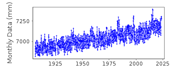
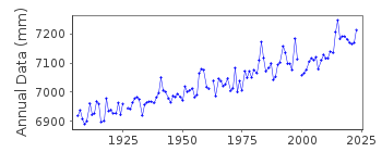
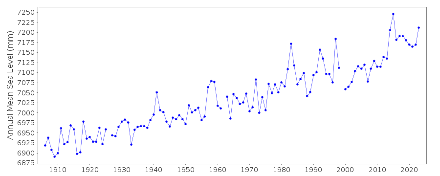
| Time span of data: | 1906 – 2025 |
| Completeness (%): | 99 |
| Date of last update: | 27 Jan 2026 |
| Green Arrow: | Current Station |
| Yellow Marker: | Neighbouring RLR Station |
| Red Marker: | Neighbouring Metric Station |
Please note: In many cases, the station position in our database is accurate to only one minute. Thus, the tide gauge may not appear to be on the coast.
Tide Gauge Data
Additional Data Sources (guide to additional data sources)
Nearby GNSS Stations from SONEL: P475, PLO6, PLO3, PLO5Nearby Real Time Stations from VLIZ: sand
Fast Delivery Data from UHSLC station 569: hourly and daily
Research Quality Data from UHSLC station 569: hourly and daily
Station Documentation
Link to RLR information.Documentation added 1991-06-11
San Diego 823/081 RLR(1973) is 10.2m below BM14A(1942)Documentation added 2011-08-24
Using NOAA data the RLR digram has been re-drawn. Primary benchmark is now 12 1926 6.325m above gauge datum. The previously used benchmark BM 14A official name BM 14 A RESET 1943 as appears on the NOAA website has a value of 5.148m above TGZ in the NOAA report of 3.6.1991 and 5.150m in the report of 21.4.2003.For information: data values for the early 1980's may look high in comparison. This could be due to the El Nino Southern Oscillation (ENSO) as it is mirrored along the Californian coast.
Data Authority
N.O.A.A. / N.O.S.N/oes33, Ssmc4, Room 6531
1305 East-West Highway
Silver Spring,
MD 20910

![]()
![]()
![]()
