Data
- Obtaining
- Supplying
- High-Frequency
- Bottom Pressure Records
- Other Long Records
- GLOSS/ODINAFRICA Calibration Data
Donate
Donate to PSMSL
Data Notes
- Individual Station Data and Plot Notes
- Referencing the Data Set
- PSMSL Help File
- 2010 Changes to the PSMSL Data Files
Extracted from Database
25 Aug 2025
Station Information
| Station ID: | 1630 |
| Latitude: | -18.516667 |
| Longitude: | 146.383333 |
| Coastline code: | 680 |
| Station code: | 47 |
| Country: | AUSTRALIA |
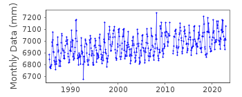
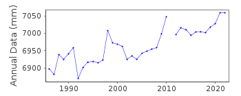
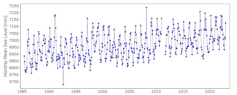
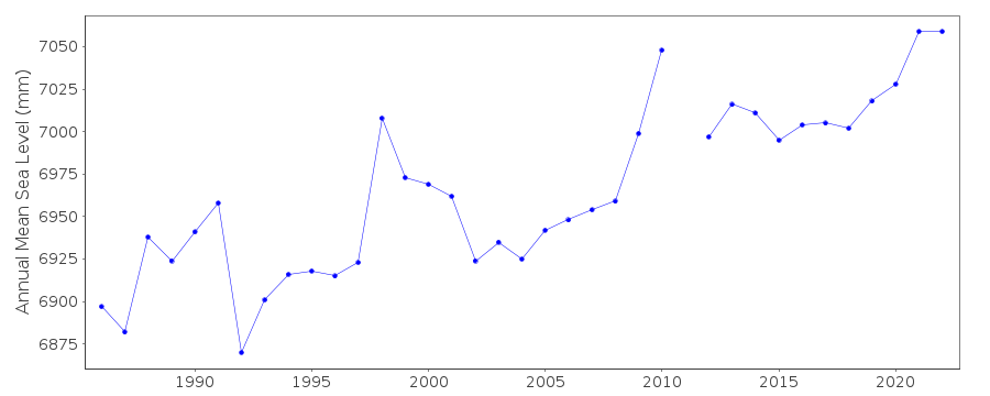
| Time span of data: | 1985 – 2023 |
| Completeness (%): | 97 |
| Date of last update: | 20 Mar 2025 |
| Green Arrow: | Current Station |
| Yellow Marker: | Neighbouring RLR Station |
| Red Marker: | Neighbouring Metric Station |
Please note: In many cases, the station position in our database is accurate to only one minute. Thus, the tide gauge may not appear to be on the coast.
Tide Gauge Data
Station Documentation
Link to RLR information.Documentation added 1995-05-02
Station density along some sections of the Australian coast has meant that station codes 601 onwards have been re-ordered compared to those in earlier versions of the PSMSL data set.Documentation added 1996-05-17
Revised data for 1985-1986 received from the National Tidal Centre, Bureau of Meteorology, South AustraliaDocumentation added 2010-08-24
Data supplier has confirmed that tide gauge zero for datum is LAT, and benchmark H&M BM14 is 5.543 m above LAT. RLR (2009) has been defined as 10.6 m below H&M BM14Documentation added 2021-02-05
The latest data from the NTC available to download for Lucinda is that for 2019.Data Authority
National Tidal CentreBureau of Meteorology
PO Box 421
Kent Town 5071
South Australia
Documentation added 2010-08-12
Formerly known as the National Tidal Facility

![]()
![]()
![]()
