Data
- Obtaining
- Supplying
- High-Frequency
- Bottom Pressure Records
- Other Long Records
- GLOSS/ODINAFRICA Calibration Data
Donate
Donate to PSMSL
Data Notes
- Individual Station Data and Plot Notes
- Referencing the Data Set
- PSMSL Help File
- 2010 Changes to the PSMSL Data Files
Extracted from Database
03 Mar 2025
WARNING: QCFLAG EXISTS. PLEASE READ THE DOCUMENTATION.
Station Information
| Station ID: | 1632 |
| Latitude: | 52.934361 |
| Longitude: | 1.301639 |
| Coastline code: | 170 |
| Station code: | 66 |
| Country: | UNITED KINGDOM |
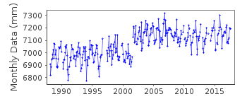
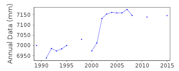
| Time span of RLR data: | 1988 – 2017 |
| RLR completeness (%): | 89 |
| Time span of metric data: | 1985 – 2017 |
| Metric completeness (%): | 86 |
| Date of last update: | 06 Jun 2018 |
| Green Arrow: | Current Station |
| Yellow Marker: | Neighbouring RLR Station |
| Red Marker: | Neighbouring Metric Station |
Please note: In many cases, the station position in our database is accurate to only one minute. Thus, the tide gauge may not appear to be on the coast.
Tide Gauge Data
Additional Data Sources (guide to additional data sources)
Nearby GNSS Stations from SONEL: WEYBNearby Real Time Stations from VLIZ: crom
Station Documentation
Link to RLR information.Documentation added 1993-09-22
Cromer 170/066 RLR(1992) is 14.3m below BM TG 2193 4233Documentation added 1994-07-20
Gauge from 1985 was an Aanderaa pressure system, replaced by an "A Class" bubbler in March 1988.Documentation added 1998-05-28
August-September 1996: doubtful datumDocumentation added 2001-01-02
Recent work on vertical land movements in the UK can be found from the University of Nottingham web site:http://ukcogr.iessg.nottingham.ac.uk/~eosi/Documentation added 2002-03-13
Pressure point moved 6th October 2001, resulting in possible datum 'jump'.Documentation added 2006-11-15
Historic tide gauge information: The gauge installed in 1988 was levelled by an external company and was later found to be .2m out. Following this a temporary gauge was fitted with the datum being based on the previous value until the new gauge with 3 sensors fitted in 2001.Documentation added 2009-01-28
Complete station flagged as suspect.Documentation added 2014-07-02
From mid July 2012 the primary channel was reading ~50mm high. The mid tide tube had been severed and the full tide tubes damaged. Following a visit in Dec. 2012 the primary channel was again functioning.Documentation added 2015-05-06
There were problems with the gauge throughout 2014. During Jan-Apr readings were in the order of 20-30mm high while in July and August HWs appeared low. From September onwards it was suspected that the gauge was blocking. TGI were at site on four separate occasions. No levelling was carried out during 2014.Data Authority
Environment AgencyHorizon House
Deanery Road
BS1 5AH
Bristol

![]()
![]()
![]()
