Data
- Obtaining
- Supplying
- High-Frequency
- Bottom Pressure Records
- Other Long Records
- GLOSS/ODINAFRICA Calibration Data
Donate
Donate to PSMSL
Data Notes
- Individual Station Data and Plot Notes
- Referencing the Data Set
- PSMSL Help File
- 2010 Changes to the PSMSL Data Files
Extracted from Database
11 May 2026
WARNING: QCFLAG EXISTS. PLEASE READ THE DOCUMENTATION.
Station Information
| Station ID: | 169 |
| Latitude: | 9.35 |
| Longitude: | -79.916667 |
| GLOSS ID: | 208 |
| Coastline code: | 904 |
| Station code: | 11 |
| Country: | PANAMA |
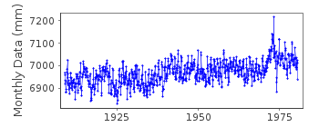
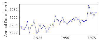
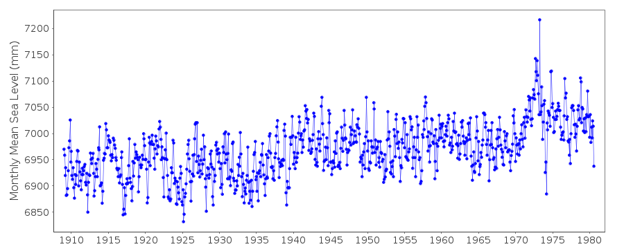
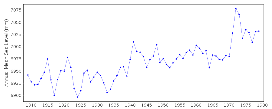
| Time span of RLR data: | 1909 – 1980 |
| RLR completeness (%): | 100 |
| Time span of metric data: | 1909 – 2010 |
| Metric completeness (%): | 94 |
| Date of last update: | 16 Jan 2012 |
| Green Arrow: | Current Station |
| Yellow Marker: | Neighbouring RLR Station |
| Red Marker: | Neighbouring Metric Station |
Please note: In many cases, the station position in our database is accurate to only one minute. Thus, the tide gauge may not appear to be on the coast.
Tide Gauge Data
Additional Data Sources (guide to additional data sources)
Nearby GNSS Stations from SONEL: ACP1Fast Delivery Data from UHSLC station 266: hourly and daily
Research Quality Data from UHSLC station 266: hourly and daily
Station Documentation
Link to RLR information.Documentation added 1993-03-17
Possible datum shift in RLR record at around 1940.Documentation added 1993-07-12
Cristobal 904/011 RLR(1964) is 8.8m below PBM 1A CristobalDocumentation added 1995-09-08
See comments for CCODE = 840 concerning sea level difference either side of the Panama Canal.Documentation added 1999-05-17
Cristobal data were considered to be affected by problems with automatic tide recorders in the early 1970s and several years of MSL look high compared to nearby stations e.g. Cartagena.Station moved to Coco Solo (PSMSL code 904/006) in October 1980.
Data Authority
Panama Canal CommissionEngineering Division
Unit 2300
Apo AA 34011-2300

![]()
![]()
![]()
