Data
- Obtaining
- Supplying
- High-Frequency
- Bottom Pressure Records
- Other Long Records
- GLOSS/ODINAFRICA Calibration Data
Donate
Donate to PSMSL
Data Notes
- Individual Station Data and Plot Notes
- Referencing the Data Set
- PSMSL Help File
- 2010 Changes to the PSMSL Data Files
Extracted from Database
03 Mar 2025
WARNING: QCFLAG EXISTS. PLEASE READ THE DOCUMENTATION.
Station Information
| Station ID: | 1730 |
| Latitude: | 9.55 |
| Longitude: | 112.88 |
| Coastline code: | 610 |
| Station code: | 3 |
| Country: | CHINA |
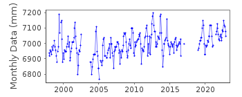
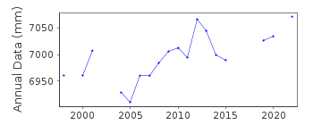
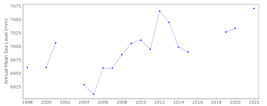
| Time span of RLR data: | 1998 – 2022 |
| RLR completeness (%): | 83 |
| Time span of metric data: | 1988 – 2022 |
| Metric completeness (%): | 79 |
| Date of last update: | 28 Mar 2023 |
| Green Arrow: | Current Station |
| Yellow Marker: | Neighbouring RLR Station |
| Red Marker: | Neighbouring Metric Station |
Please note: In many cases, the station position in our database is accurate to only one minute. Thus, the tide gauge may not appear to be on the coast.
Tide Gauge Data
Station Documentation
Link to RLR information.Documentation added 1998-04-21
data for 1990-94 revised with values in dataset received in April 1998Documentation added 2003-02-18
Data for 1997 were replaced by the new data obtained from University of Hawaii. Data for 1998-2002 are obtained from University of Hawaii.Documentation added 2008-01-22
Data for the period 2003-2006 was downloaded from UHSLC The values were corrected for the Hawaii adjusted offset.Documentation added 2008-01-29
Following the confirmation of bench mark details an RLR value of 5732 was applied to the data from 1990 onwards.Documentation added 2008-01-29
Following confirmation of bench mark details RLR value 3688 was added to all data post 1998. See Elaines letter of 23.4.98. However the plot still looks suspect so the station was flagged.Documentation added 2009-02-11
Following confirmation from the Chinese authority queried value for Nansha November 2008 was corrected from 384cm to 332cm. Plot now looks OK.Documentation added 2019-02-05
There is no 2018 data available for station Nansha.Data Authority
National Marine Data and Information Service (NMDIS)No. 93 Liuwei Road
Tianjin 300171

![]()
![]()
![]()
