Data
- Obtaining
- Supplying
- High-Frequency
- Bottom Pressure Records
- Other Long Records
- GLOSS/ODINAFRICA Calibration Data
Donate
Donate to PSMSL
Data Notes
- Individual Station Data and Plot Notes
- Referencing the Data Set
- PSMSL Help File
- 2010 Changes to the PSMSL Data Files
Extracted from Database
03 Mar 2025
Station Information
| Station ID: | 1752 |
| Latitude: | 1.75 |
| Longitude: | 98.766667 |
| Coastline code: | 560 |
| Station code: | 22 |
| Country: | INDONESIA |
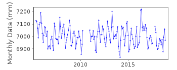
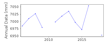
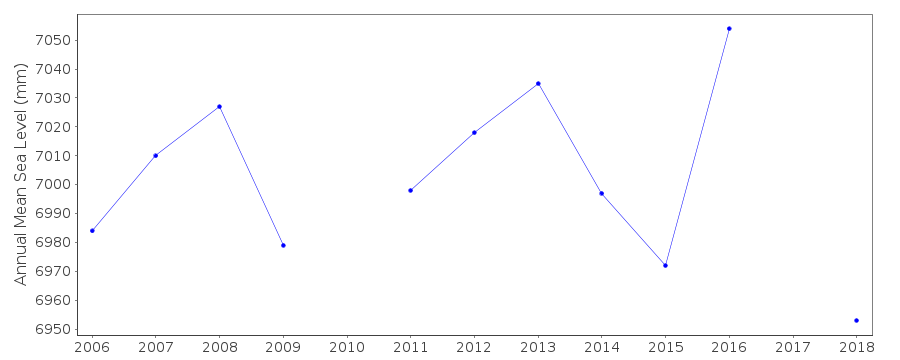
| Time span of RLR data: | 2005 – 2018 |
| RLR completeness (%): | 92 |
| Time span of metric data: | 1989 – 2018 |
| Metric completeness (%): | 87 |
| Date of last update: | 29 Jan 2020 |
| Green Arrow: | Current Station |
| Yellow Marker: | Neighbouring RLR Station |
| Red Marker: | Neighbouring Metric Station |
Please note: In many cases, the station position in our database is accurate to only one minute. Thus, the tide gauge may not appear to be on the coast.
Tide Gauge Data
Additional Data Sources (guide to additional data sources)
Fast Delivery Data from UHSLC station 122: hourly and dailyResearch Quality Data from UHSLC station 122: hourly and daily
Station Documentation
Link to RLR information.Documentation added 1995-08-29
Destructive earthquakes and tsunamis occurred in Indonesia on 3 June and 6 October 1994 - see Earth System Monitor, 5(4), June 1995.Documentation added 2006-07-07
Data received from University of Hawaii Sea Level CenterDocumentation added 2015-10-20
Using information from the UHSLC levelling sheet Sibolga II has been made RLR for 2005 onwards. Primary benchmark is UH1 5.303m above the datum. Using the updated JASL data the complete dataset has been reloaded.Data Authority
University of Hawaii Sea Level CenterDepartment of Oceanography Division of Natural Sciences
1000 Pope Road
Honolulu
Hawaii 96822

![]()
![]()
![]()
