Data
- Obtaining
- Supplying
- High-Frequency
- Bottom Pressure Records
- Other Long Records
- GLOSS/ODINAFRICA Calibration Data
Donate
Donate to PSMSL
Data Notes
- Individual Station Data and Plot Notes
- Referencing the Data Set
- PSMSL Help File
- 2010 Changes to the PSMSL Data Files
Extracted from Database
11 May 2026
Station Information
| Station ID: | 1753 |
| Latitude: | 4.183333 |
| Longitude: | 73.533333 |
| GLOSS ID: | 28 |
| Coastline code: | 454 |
| Station code: | 11 |
| Country: | MALDIVES |
| Time span of data: | 1989 – 2017 |
| Completeness (%): | 93 |
| Date of last update: | 29 Jan 2020 |
| Green Arrow: | Current Station |
| Yellow Marker: | Neighbouring RLR Station |
| Red Marker: | Neighbouring Metric Station |
Please note: In many cases, the station position in our database is accurate to only one minute. Thus, the tide gauge may not appear to be on the coast.
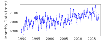
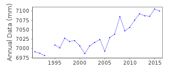
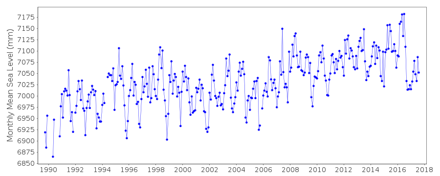
Tide Gauge Data
Additional Data Sources (guide to additional data sources)
Nearby GNSS Stations from SONEL: MALE, MALD, HULENearby Real Time Stations from VLIZ: Male2
Fast Delivery Data from UHSLC station 108: hourly and daily
Research Quality Data from UHSLC station 108: hourly and daily
Station Documentation
Link to RLR information.Documentation added 1993-03-31
data received from toga officeDocumentation added 1996-10-15
instrument type: analog (BUB); digital (ENC,ENB)Metercraft Bubbler (BUB)Handar 436-A, Encoder (ENC),Handar 436-B (ENB); float gaugesDocumentation added 2010-11-18
The complete dataset 1989- Sept. 2010 has been received from UHSLC. After checking with existing data values these data have been loaded onto the database. RLR remains 5.109m.Documentation added 2013-10-15
Complete UHSLC dataset 1989-2012 added to the database. A number of values had been revised/added.Documentation added 2015-10-29
Complete updated JASL data through to 2014 loaded onto the database. UHSLC is now the main data supplier for this station. The previous authority was the Meteorological Station, Maldives.Data Authority
University of Hawaii Sea Level CenterDepartment of Oceanography Division of Natural Sciences
1000 Pope Road
Honolulu
Hawaii 96822

![]()
![]()
![]()
