Data
- Obtaining
- Supplying
- High-Frequency
- Bottom Pressure Records
- Other Long Records
- GLOSS/ODINAFRICA Calibration Data
Donate
Donate to PSMSL
Data Notes
- Individual Station Data and Plot Notes
- Referencing the Data Set
- PSMSL Help File
- 2010 Changes to the PSMSL Data Files
Extracted from Database
01 Jun 2026
Station Information
| Station ID: | 1754 |
| Latitude: | 16.933333 |
| Longitude: | 54 |
| GLOSS ID: | 4 |
| Coastline code: | 487 |
| Station code: | 1 |
| Country: | OMAN |
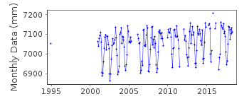
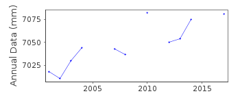
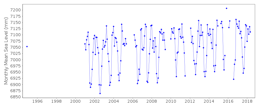
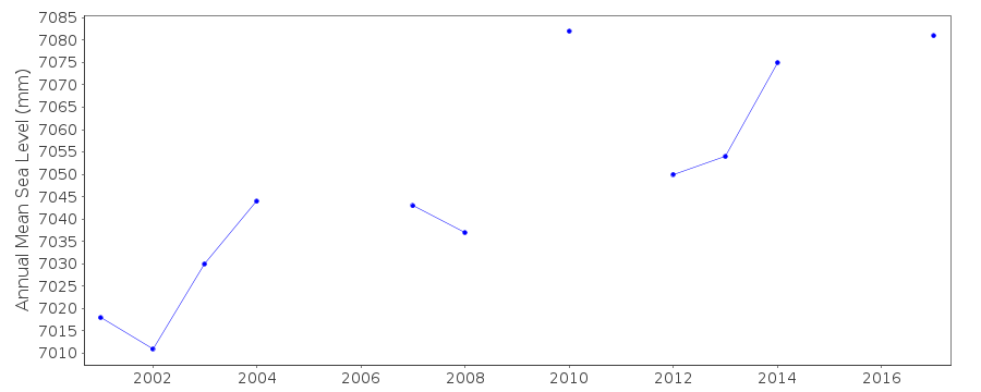
| Time span of RLR data: | 1994 – 2018 |
| RLR completeness (%): | 60 |
| Time span of metric data: | 1989 – 2018 |
| Metric completeness (%): | 81 |
| Date of last update: | 29 Jan 2020 |
| Green Arrow: | Current Station |
| Yellow Marker: | Neighbouring RLR Station |
| Red Marker: | Neighbouring Metric Station |
Please note: In many cases, the station position in our database is accurate to only one minute. Thus, the tide gauge may not appear to be on the coast.
Tide Gauge Data
Additional Data Sources (guide to additional data sources)
Nearby Real Time Stations from VLIZ: salaFast Delivery Data from UHSLC station 114: hourly and daily
Research Quality Data from UHSLC station 114: hourly and daily
Station Documentation
Link to RLR information.Documentation added 1993-03-31
data received from toga officeDocumentation added 1996-10-15
instrument type: Fischer and Porter Analog-to-Digital Recorder (ADR) model 1551 Handar Encoder (ENC)Documentation added 1998-12-31
data for 1996 revised in Decemebr 1998Documentation added 2010-11-18
Complete dataset 1989-2009 received from UHSLC. Data values were checked with existing data - looks the same apart from 2003, where the previous dataset ended, odd 1mm differences through the year. Complete dataset was loaded onto the database. Station is currently Metric.Documentation added 2013-10-15
Complete UHSLC dataset 1989-2012 added to the database.Documentation added 2015-10-29
Complete UHSLC updated dataset reloaded onto the database. using UH levelling sheets Salalah has been made RLR from 2001 data.Data Authority
University of Hawaii Sea Level CenterDepartment of Oceanography Division of Natural Sciences
1000 Pope Road
Honolulu
Hawaii 96822

![]()
![]()
![]()
