Data
- Obtaining
- Supplying
- High-Frequency
- Bottom Pressure Records
- Other Long Records
- GLOSS/ODINAFRICA Calibration Data
Donate
Donate to PSMSL
Data Notes
- Individual Station Data and Plot Notes
- Referencing the Data Set
- PSMSL Help File
- 2010 Changes to the PSMSL Data Files
Extracted from Database
09 Feb 2026
Station Information
| Station ID: | 1761 |
| Latitude: | -31.825556 |
| Longitude: | 115.738583 |
| Coastline code: | 680 |
| Station code: | 472 |
| Country: | AUSTRALIA |
| Time span of RLR data: | 1991 – 2025 |
| RLR completeness (%): | 93 |
| Time span of metric data: | 1990 – 2025 |
| Metric completeness (%): | 93 |
| Date of last update: | 11 Jun 2025 |
| Green Arrow: | Current Station |
| Yellow Marker: | Neighbouring RLR Station |
| Red Marker: | Neighbouring Metric Station |
Please note: In many cases, the station position in our database is accurate to only one minute. Thus, the tide gauge may not appear to be on the coast.
Tide Gauge Data
Additional Data Sources (guide to additional data sources)
Nearby GNSS Stations from SONEL: HIL1Nearby Real Time Stations from VLIZ: hill
Research Quality Data from UHSLC station 132: hourly and daily
Station Documentation
Link to RLR information.Documentation added 1995-05-02
Station density along some sections of the Australian coast has meant that station codes 601 onwards have been re-ordered compared to those in earlier versions of the PSMSL data set.Documentation added 2000-04-10
This is a "baseline station" of the Australian National Tidal Facility.Documentation added 2000-04-10
Hillarys 680/472 RLR(2000) is 10.511m below HZ879Documentation added 2011-09-06
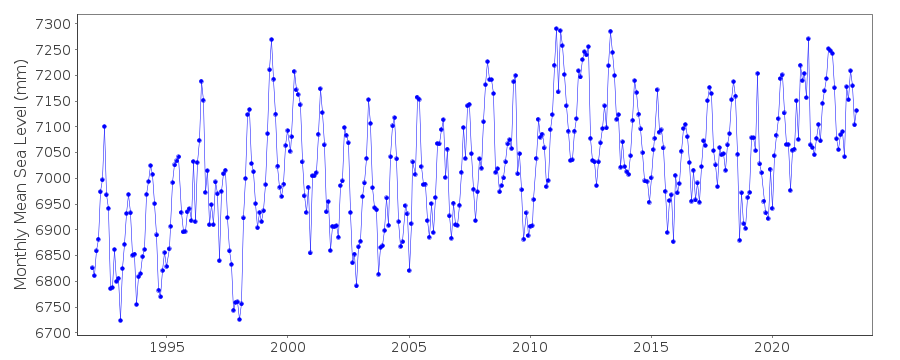
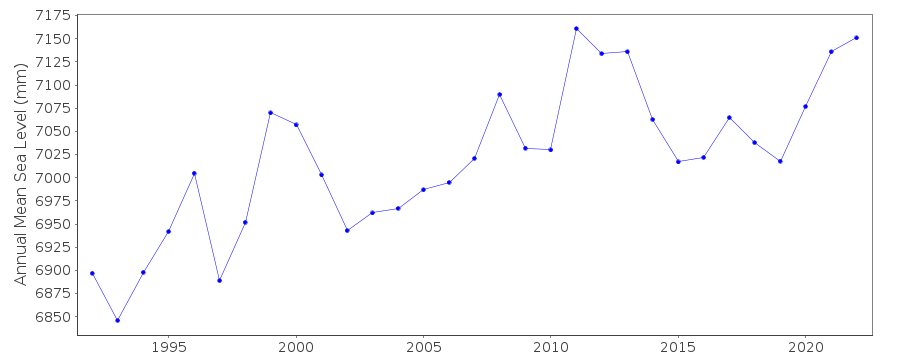
The Hillarys record suggests that sea level is rising relatively fast due to local submergence from compaction of the coastal sandy location and significant ground water extraction, see the chapter by Deng et al. entitled 'Satellite Altimetry for Geodetic, Oceanographic and Climate Sudies in the Australian Region' in the book Coastal Altimetry (Wiley, 2011)Documentation added 2011-10-24
Using information from the National Tidal Centre, Australia the RLR diagram has been revised. Benchmark HZ879 is 4.211m above TGZ. Benchmark Hamersley 130 T1 is 4.895m above TGZ and the national datum reference is 0.763m above tgz. The RLR factor is 6.3m.Documentation added 2014-02-11
The high rate of sea level rise at Hillarys during the two decades since the early 1990s has been linked to groundwater withdrawal, see Burgette et al. (2013 Geophysical Journal International).Documentation added 2025-06-11
The Hillarys station was removed in July 2023 to allow for wharf refurbishment, following which it was reinstated at a new height and resurveyed in April 2024. There was a long-standing 80 mm discrepancy in the contact point prior to July 2023 (levelling surveys were made to the underside of a bolt on the tide gauge Hammersly 130 T1, whereas sea level sensors were positioned relative to the topside of the bolt). This change has been applied to the whole dataset starts Nov 1991.Data Authority
National Tidal CentreBureau of Meteorology
PO Box 421
Kent Town 5071
South Australia
Documentation added 2010-08-12
Formerly known as the National Tidal Facility

![]()
![]()
![]()
