Data
- Obtaining
- Supplying
- High-Frequency
- Bottom Pressure Records
- Other Long Records
- GLOSS/ODINAFRICA Calibration Data
Donate
Donate to PSMSL
Data Notes
- Individual Station Data and Plot Notes
- Referencing the Data Set
- PSMSL Help File
- 2010 Changes to the PSMSL Data Files
Extracted from Database
21 Apr 2025
Station Information
| Station ID: | 1808 |
| Latitude: | 43.35731 |
| Longitude: | -8.38933 |
| GLOSS ID: | 243 |
| Coastline code: | 200 |
| Station code: | 32 |
| Country: | SPAIN |
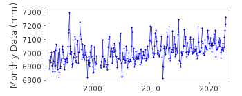
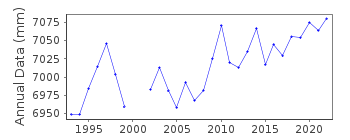
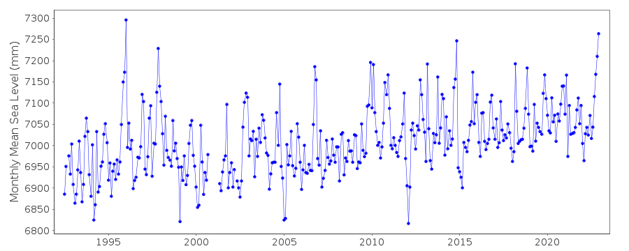
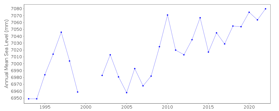
| Time span of data: | 1992 – 2022 |
| Completeness (%): | 96 |
| Link to ellipsoid: | Available |
| Date of last update: | 11 Jul 2023 |
| Green Arrow: | Current Station |
| Yellow Marker: | Neighbouring RLR Station |
| Red Marker: | Neighbouring Metric Station |
Please note: In many cases, the station position in our database is accurate to only one minute. Thus, the tide gauge may not appear to be on the coast.
Tide Gauge Data
Additional Data Sources (guide to additional data sources)
Nearby GNSS Stations from SONEL: ACORNearby Real Time Stations from VLIZ: cor2
Fast Delivery Data from UHSLC station 830: hourly and daily
Research Quality Data from UHSLC station 830: hourly and daily
Station Documentation
Link to RLR information.Documentation added 1999-08-20
Gauge type=SONAR acousticDocumentation added 2000-04-25
La Coruna III 200/032 RLR(1995) is 10.3m below BM SSMDocumentation added 2005-05-23
A paper by Marcos et al (JGR Volume 11, 2005) provides an overview of the tide gauge records on the northern coast of Spain.Documentation added 2013-04-10
The old SRD acoustic gauge at La Coruna has been replaced by a new MIROS radar gauge. Because of a sudden malfunction towards the end of the operation of the SRD gauge both old and new gauges were running in parallel for just a 4 month period 25.04.2008-28.10.2008 for inter-comparison purposes. A bias (mean difference) of -2.15cm was calculated between the two gauges. See paper B. Perez et al ' Overlapping sea level time series measured using different technologies: an example from the REDMAR Spanish network'.Documentation added 2014-01-13
Further investigation from Puertos del Estado established that the bias between the old and new datasets was due to a problem with the old Acoustic gauge. The old dataset has been revised because of this. Whole dataset was re-entered onto the database.Documentation added 2014-04-28
At the request of Puertos del Estado the latitude and longitude have been changed from 43.366667 -8.383333 which derives from the previously supplied degrees and minutes value to 43.35731 -8.38933 which is the position of the new gauge in decimal degrees.Documentation added 2014-10-08
During 2013 an error was detected with the dataset for REDMAR station Coruna. After lengthy investigation the complete dataset has been revised by Puertos del Estado.Documentation added 2016-01-20
On instructions from Begona at PE the complete dataset 1992-2014 has been reloaded. It was realised there were problems from the istallation of the MIROS gauge and when this was replaced in Nov 2011 due to delamination. Following this a new time series has been generated with a datum change of 4.5cm for data 2007-2011 and 2.5cm for the historic data 1992-2007. PE has confirmed that all changes and corrections have been documented internally.Data Authority
Puertos del EstadoÁrea de Conocimiento y Análisis del Medio Físico
Avda. Del Partenón, 10
28042, Madrid
Documentation added 2001-03-06
The Area de Conocimiento y Analisis del Medio Fisico wasformerly known as the Departamento de Clima Maritimo.

![]()
![]()
![]()
