Data
- Obtaining
- Supplying
- High-Frequency
- Bottom Pressure Records
- Other Long Records
- GLOSS/ODINAFRICA Calibration Data
Donate
Donate to PSMSL
Data Notes
- Individual Station Data and Plot Notes
- Referencing the Data Set
- PSMSL Help File
- 2010 Changes to the PSMSL Data Files
Extracted from Database
03 Mar 2025
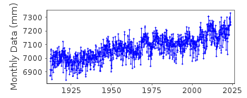
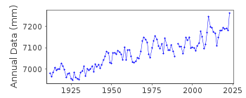
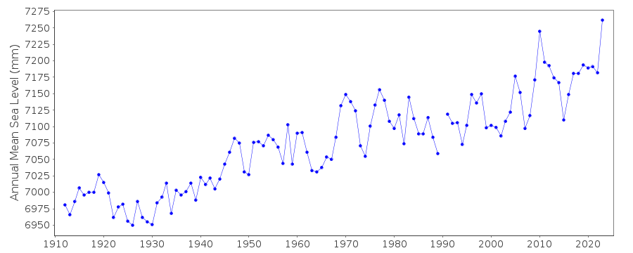
Station Information
| Station ID: | 183 |
| Latitude: | 43.656667 |
| Longitude: | -70.246667 |
| Coastline code: | 960 |
| Station code: | 181 |
| Country: | UNITED STATES |
| Time span of data: | 1912 – 2024 |
| Completeness (%): | 100 |
| Date of last update: | 23 Jan 2025 |
| Green Arrow: | Current Station |
| Yellow Marker: | Neighbouring RLR Station |
| Red Marker: | Neighbouring Metric Station |
Please note: In many cases, the station position in our database is accurate to only one minute. Thus, the tide gauge may not appear to be on the coast.
Tide Gauge Data
Additional Data Sources (guide to additional data sources)
Nearby Real Time Stations from VLIZ: ptmeResearch Quality Data from UHSLC station 252: hourly and daily
Station Documentation
Link to RLR information.Documentation added 1991-06-11
Portland (Maine) 960/181 RLR(1964) is 11.4m below BM31Documentation added 2011-08-17
Using NOAA data the RLR diagram has been re-drawn. The Primary benchmark BM 31 8.406m above gauge datum remains the same but has now been given the full name ELEV 14.501 FT TIDAL 31 as appears on the NOAA website.Data Authority
N.O.A.A. / N.O.S.N/oes33, Ssmc4, Room 6531
1305 East-West Highway
Silver Spring,
MD 20910

![]()
![]()
![]()
