Data
- Obtaining
- Supplying
- High-Frequency
- Bottom Pressure Records
- Other Long Records
- GLOSS/ODINAFRICA Calibration Data
Donate
Donate to PSMSL
Data Notes
- Individual Station Data and Plot Notes
- Referencing the Data Set
- PSMSL Help File
- 2010 Changes to the PSMSL Data Files
Extracted from Database
03 Mar 2025
Station Information
| Station ID: | 1832 |
| Latitude: | 51.55 |
| Longitude: | -2.987444 |
| Coastline code: | 170 |
| Station code: | 173 |
| Country: | UNITED KINGDOM |
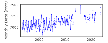
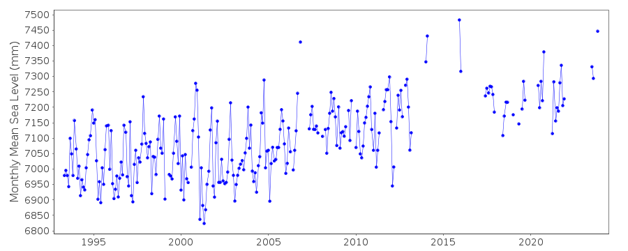
| Time span of data: | 1993 – 2024 |
| Completeness (%): | 67 |
| Date of last update: | 19 Feb 2025 |
| Green Arrow: | Current Station |
| Yellow Marker: | Neighbouring RLR Station |
| Red Marker: | Neighbouring Metric Station |
Please note: In many cases, the station position in our database is accurate to only one minute. Thus, the tide gauge may not appear to be on the coast.
Tide Gauge Data
Additional Data Sources (guide to additional data sources)
Nearby GNSS Stations from SONEL: CARFNearby Real Time Stations from VLIZ: npor
Station Documentation
Link to RLR information.Documentation added 2000-04-25
Newport, Gwent 170/173 RLR(1995) is 15.5m below BM AUX 3Documentation added 2001-01-02
Recent work on vertical land movements in the UK can be found from the University of Nottingham web site: http://ukcogr.iessg.nottingham.ac.uk/~eosi/Documentation added 2014-07-03
TGI visited the site on 08.02.2013 to change the compressor. During March 2013 the primary channel was blocking and reading up to ~80mm high. From April to September the primary channel was blocking up to 70mm high. TGI re-visited the site on 05.12.2013 and carried out general maintenance.Documentation added 2015-06-02
Channel2 was reading ~40mm high most has been flagged during processing so for most of the year there is no viable data available. Channel1 the backup channel was working throughout. TGI were at site 18.06.14 for general maintenance and to change the compressor.Data Authority
Environment AgencyHorizon House
Deanery Road
BS1 5AH
Bristol

![]()
![]()
![]()
