Data
- Obtaining
- Supplying
- High-Frequency
- Bottom Pressure Records
- Other Long Records
- GLOSS/ODINAFRICA Calibration Data
Donate
Donate to PSMSL
Data Notes
- Individual Station Data and Plot Notes
- Referencing the Data Set
- PSMSL Help File
- 2010 Changes to the PSMSL Data Files
Extracted from Database
03 Mar 2025
Station Information
| Station ID: | 1841 |
| Latitude: | -17.755333 |
| Longitude: | 168.307694 |
| GLOSS ID: | 348 |
| Coastline code: | 741 |
| Station code: | 2 |
| Country: | VANUATU |
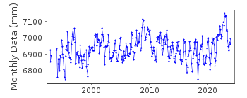
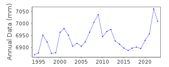
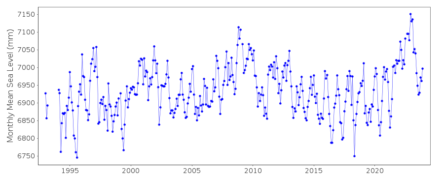
| Time span of data: | 1993 – 2023 |
| Completeness (%): | 97 |
| Link to ellipsoid: | Available |
| Date of last update: | 05 Feb 2024 |
| Green Arrow: | Current Station |
| Yellow Marker: | Neighbouring RLR Station |
| Red Marker: | Neighbouring Metric Station |
Please note: In many cases, the station position in our database is accurate to only one minute. Thus, the tide gauge may not appear to be on the coast.
Tide Gauge Data
Additional Data Sources (guide to additional data sources)
Nearby GNSS Stations from SONEL: PTVL, VANUNearby Real Time Stations from VLIZ: vanu
Fast Delivery Data from UHSLC station 46: hourly and daily
Research Quality Data from UHSLC station 46: hourly and daily
Station Documentation
Link to RLR information.Documentation added 1998-01-13
National Tidal Facility SEAFRAME stationDocumentation added 2002-10-16
Approx. 11cm rise in sea level 2nd Jan 2002 following earthquake.Documentation added 2010-09-20
Benchmark VAN 1 is 2.854m above TGZ (ORSTOM) RLR (2008) has been defined as 8.9m below VAN 1Documentation added 2011-03-15
From data available from the VLIZ site in Ostende a tsunami can be seen 29-30 September 2009.Data Authority
National Tidal CentreBureau of Meteorology
PO Box 421
Kent Town 5071
South Australia
Documentation added 2010-08-12
Formerly known as the National Tidal Facility

![]()
![]()
![]()
