Data
- Obtaining
- Supplying
- High-Frequency
- Bottom Pressure Records
- Other Long Records
- GLOSS/ODINAFRICA Calibration Data
Donate
Donate to PSMSL
Data Notes
- Individual Station Data and Plot Notes
- Referencing the Data Set
- PSMSL Help File
- 2010 Changes to the PSMSL Data Files
Extracted from Database
11 May 2026
Station Information
| Station ID: | 185 |
| Latitude: | -47.75 |
| Longitude: | -65.916667 |
| GLOSS ID: | 190 |
| Coastline code: | 860 |
| Station code: | 11 |
| Country: | ARGENTINA |
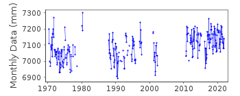
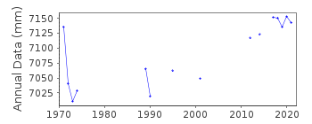
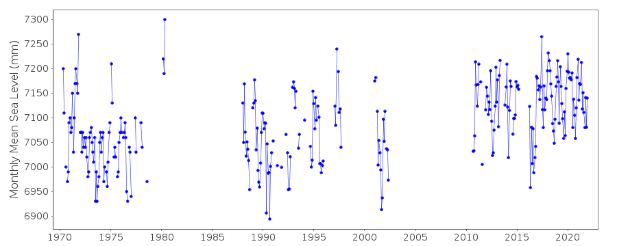
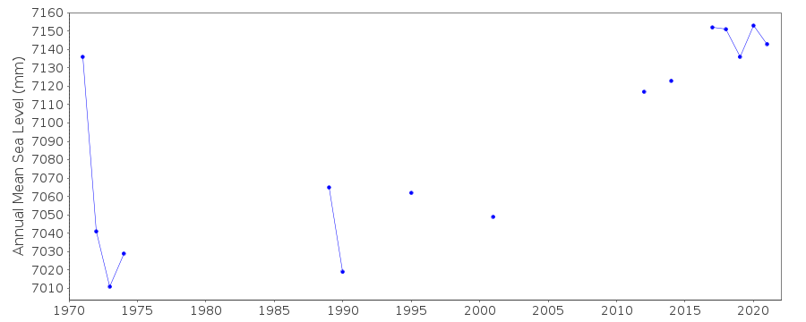
| Time span of RLR data: | 1970 – 2021 |
| RLR completeness (%): | 45 |
| Time span of metric data: | 1912 – 2021 |
| Metric completeness (%): | 42 |
| Date of last update: | 08 Feb 2023 |
| Green Arrow: | Current Station |
| Yellow Marker: | Neighbouring RLR Station |
| Red Marker: | Neighbouring Metric Station |
Please note: In many cases, the station position in our database is accurate to only one minute. Thus, the tide gauge may not appear to be on the coast.
Tide Gauge Data
Additional Data Sources (guide to additional data sources)
Nearby GNSS Stations from SONEL: PDE3, PDE2, PDESNearby Real Time Stations from VLIZ: dese
Fast Delivery Data from UHSLC station 286: hourly and daily
Research Quality Data from UHSLC station 286: hourly and daily
Station Documentation
Link to RLR information.Documentation - date unknown
Also known as DeseadoDocumentation added 1993-07-12
Puerto Deseado 860/011 RLR(1973) is 12.2m below TGBMDocumentation added 2001-03-21
Puerto Deseado had datum problems 1996 onwards. The equipment was temporarily removed 22/7/1999 because of pier work.Documentation added 2015-10-21
Previously, last data we held for this station was for May 2002. The Sevicio de Hidrografia Naval have now supplied the data for Puert Deseado for 2010-2014. The data sheet comfirms that the datum and benchmarks remain the same as previously.Data Authority
Servicio de Hidrografia NavalDepartmento Oceanografia
Av. Montes de Oca 2124
1271 Buenos Aires

![]()
![]()
![]()
