Data
- Obtaining
- Supplying
- High-Frequency
- Bottom Pressure Records
- Other Long Records
- GLOSS/ODINAFRICA Calibration Data
Donate
Donate to PSMSL
Data Notes
- Individual Station Data and Plot Notes
- Referencing the Data Set
- PSMSL Help File
- 2010 Changes to the PSMSL Data Files
Extracted from Database
03 Mar 2025
Station Information
| Station ID: | 1920 |
| Latitude: | -43.94628 |
| Longitude: | -176.56116 |
| GLOSS ID: | 128 |
| Coastline code: | 690 |
| Station code: | 401 |
| Country: | NEW ZEALAND |
| Time span of data: | 2001 – 2010 |
| Completeness (%): | 77 |
| Link to ellipsoid: | Available |
| Date of last update: | 17 Nov 2010 |
| Green Arrow: | Current Station |
| Yellow Marker: | Neighbouring RLR Station |
| Red Marker: | Neighbouring Metric Station |
Please note: In many cases, the station position in our database is accurate to only one minute. Thus, the tide gauge may not appear to be on the coast.
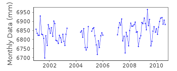
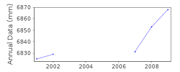
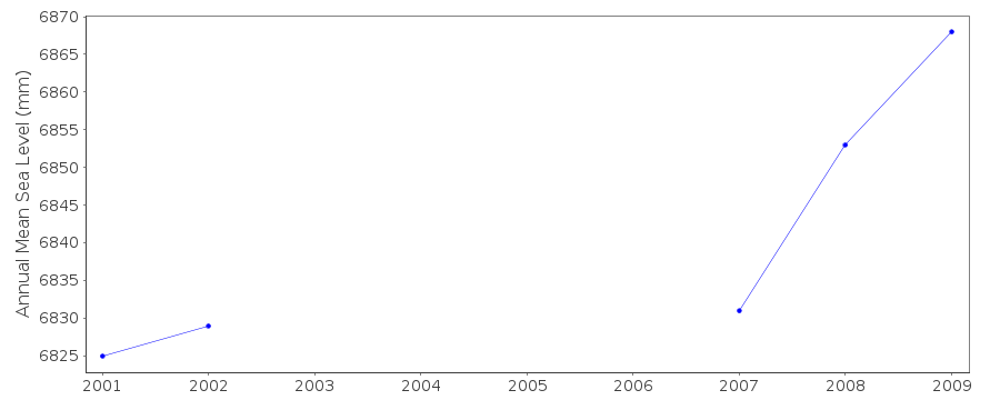
Tide Gauge Data
Additional Data Sources (guide to additional data sources)
Nearby GNSS Stations from SONEL: CHTI, OWNG, CHAT, OWMGFast Delivery Data from UHSLC station 79: hourly and daily
Research Quality Data from UHSLC station 79: hourly and daily
Station Documentation
Link to RLR information.Documentation added 2003-01-17
New data from John Hannah added 17/01/03 which supercedes old data.New data does not have any missing days information.
Old data has been backed up.
Documentation added 2003-01-17
New data from John Hannah was for Auckland II, Dunedin II,Lyttelton II and Wellington II.
Documentation added 2005-10-17
There is a new John Hannah paper referring to New Zealand data forWellington, Dunedin, Lyttelton and Auckland. The reference is:
"An updated analysis of long-term sea level change in New Zealand."
Geophysical Research Letters, V31, L03307, doi:10.1029/2003GL019166
(2004).
Documentation added 2005-11-07
Chatham Island 690/401 RLR(2001) is 9.65m below TGBM upper brass pegDocumentation added 2010-11-17
The complete dataset 2001-Sept. 2010 supplied by UHSLC. After comparing thesewith existing data values these data have been loaded onto the database. RLR
remains 5.000m.
Data Authority
University of Hawaii Sea Level CenterDepartment of Oceanography Division of Natural Sciences
1000 Pope Road
Honolulu
Hawaii 96822

![]()
![]()
![]()
