Data
- Obtaining
- Supplying
- High-Frequency
- Bottom Pressure Records
- Other Long Records
- GLOSS/ODINAFRICA Calibration Data
Donate
Donate to PSMSL
Data Notes
- Individual Station Data and Plot Notes
- Referencing the Data Set
- PSMSL Help File
- 2010 Changes to the PSMSL Data Files
Extracted from Database
03 Mar 2025
Station Information
| Station ID: | 1926 |
| Latitude: | 41.883333 |
| Longitude: | 28.016667 |
| Coastline code: | 310 |
| Station code: | 18 |
| Country: | TURKEY |
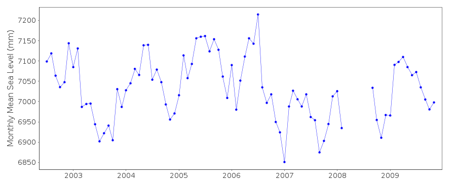
| Time span of data: | 2002 – 2009 |
| Completeness (%): | 86 |
| Date of last update: | 09 Jul 2013 |
| Green Arrow: | Current Station |
| Yellow Marker: | Neighbouring RLR Station |
| Red Marker: | Neighbouring Metric Station |
Please note: In many cases, the station position in our database is accurate to only one minute. Thus, the tide gauge may not appear to be on the coast.
Tide Gauge Data
Additional Data Sources (guide to additional data sources)
Nearby Real Time Stations from VLIZ: igneStation Documentation
Link to RLR information.Documentation added 2010-07-01
During May 2010 the entire revised dataholdings from the Turkish Sea LevelMonitoring Network were supplied to the PSMSL from the General Command of
Mapping together with full benchmark details.All previous data were replaced
included were several stations new to the PSMSL. Igneda was previously an RLR
station with TGBM MARDN-1 2.512m above Chart Datum. RLR (2003) was 7.7m below
TGBM Mardn-1. RLR factor was 5.188m.
The RLR diagram was re-created with Primary benchmark IADA-1 2.511m above TGZ.
RLR (2009) was again 7.7m below IADA-1 with an RLR factor 5.189m.
Ther is also a Secondary benchmark IADA-2 2.694m above TGZ.
Data Authority
General Directorate of MappingTlp Fakultesi Cad
06590 Cebeci/Cankaya
Ankara

![]()
![]()
![]()
