Data
- Obtaining
- Supplying
- High-Frequency
- Bottom Pressure Records
- Other Long Records
- GLOSS/ODINAFRICA Calibration Data
Donate
Donate to PSMSL
Data Notes
- Individual Station Data and Plot Notes
- Referencing the Data Set
- PSMSL Help File
- 2010 Changes to the PSMSL Data Files
Extracted from Database
03 Mar 2025
Station Information
| Station ID: | 1975 |
| Latitude: | -0.05 |
| Longitude: | -51.166667 |
| Coastline code: | 874 |
| Station code: | 171 |
| Country: | BRAZIL |
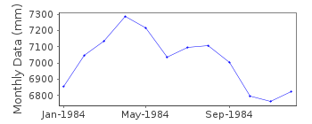
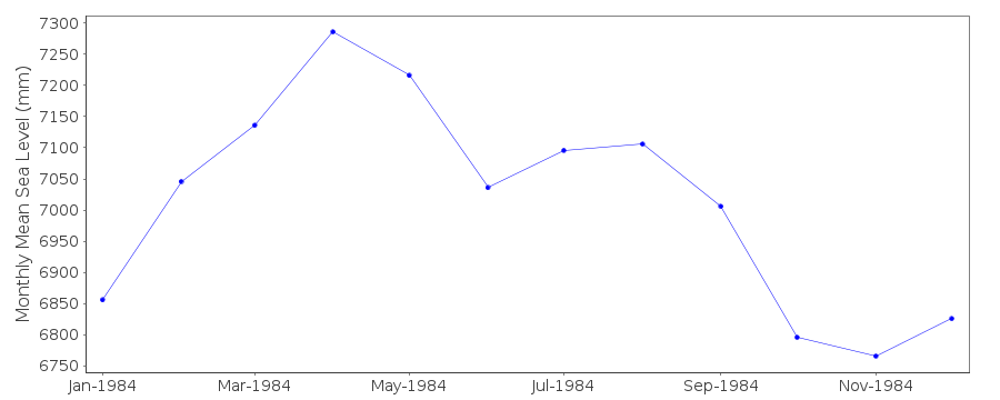
| Time span of data: | 1984 – 1984 |
| Completeness (%): | 100 |
| Date of last update: | 18 Mar 1987 |
| Green Arrow: | Current Station |
| Yellow Marker: | Neighbouring RLR Station |
| Red Marker: | Neighbouring Metric Station |
Please note: In many cases, the station position in our database is accurate to only one minute. Thus, the tide gauge may not appear to be on the coast.
Tide Gauge Data
Additional Data Sources (guide to additional data sources)
Nearby GNSS Stations from SONEL: MAPA, APS1, APSANearby Real Time Stations from VLIZ: ptos2
Research Quality Data from UHSLC station 716: hourly and daily
Research Quality Data from UHSLC station 717: hourly and daily
Station Documentation
Link to RLR information.Documentation added 1991-06-11
Santana 874/171 RLR(1984) is 12.9m below RN-3Documentation added 1993-07-12
Santana 874/171 RLR(1984) is 12.9m below RN-3Data Authority
Director of Hydrography and NaviagationRua Barao de Jaceguai,
S/No - Ponta da Armacao

![]()
![]()
![]()
