Data
- Obtaining
- Supplying
- High-Frequency
- Bottom Pressure Records
- Other Long Records
- GLOSS/ODINAFRICA Calibration Data
Donate
Donate to PSMSL
Data Notes
- Individual Station Data and Plot Notes
- Referencing the Data Set
- PSMSL Help File
- 2010 Changes to the PSMSL Data Files
Extracted from Database
13 Jul 2026
Station Information
| Station ID: | 204 |
| Latitude: | 24.811667 |
| Longitude: | 66.975 |
| GLOSS ID: | 30 |
| Coastline code: | 490 |
| Station code: | 21 |
| Country: | PAKISTAN |
| Time span of data: | 1916 – 2016 |
| Completeness (%): | 57 |
| MTL Data: | 1937-1948 |
| MTL-MSL (mm): | 10 |
| Date of last update: | 30 Nov 2017 |
| Green Arrow: | Current Station |
| Yellow Marker: | Neighbouring RLR Station |
| Red Marker: | Neighbouring Metric Station |
Please note: In many cases, the station position in our database is accurate to only one minute. Thus, the tide gauge may not appear to be on the coast.
Tide Gauge Data
Additional Data Sources (guide to additional data sources)
Fast Delivery Data from UHSLC station 147: hourly and dailyResearch Quality Data from UHSLC station 147: hourly and daily
Station Documentation
Link to RLR information.Documentation added 1993-07-29
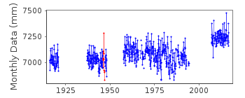
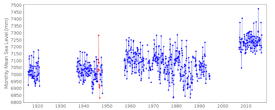
Anomalously large value June 1946 and low values at end of 1946 (just before a data gap) - correct as received from authority.Documentation added 1994-08-04
For a discussion of interannual variability of sea level along the coasts of Pakistan and India, see Clarke and Liu, Journal of Physical Oceanography, 24, 1224, 1994.Documentation added 2002-06-14
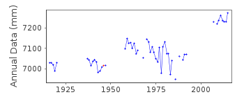
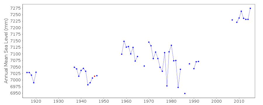
Data for 1916-20 are MSL and were obtained from the Survey of India, Dehra Dun. Data 1937-48 are MTL (Mean Tide Level) and were also obtained from the Survey of India. Data 57 onwards are MSL. 1957-65 were obtained from the Pakistan Meteorological Department, while 1966-85 from National Institute of Oceanography. 1986-87 were obtained from the University ofHawaii Sea Level Center using data supplied by the NIO.
Documentation added 2002-06-17
Karachi 490/021 RLR(1947) is 9.7m below BM 1PP (circa 1920)Documentation added 2002-09-25
New data from Pakistan Navy for 1987 replaces TOGA data for Jan-Apr and DecDocumentation added 2009-03-11
The gauge at Karachi has been resited and is now no longer on Manora Island. The new gauge has been levelled in to the old one. 2007/8 one minute sea level data downloaded from theIOC Sea Level Station Monitoring Facility Ostend. This is then converted to 15min. data for processing. 2007/8 monthly and annual mean sea level values have now been extracted from the data. As the relationship for the prime bench mark remains the same there is no need to alter RLR. Details of the bench marks has been derived from site installation information. Copies of these have been included in the port files and RLR file for reference.
Documentation added 2016-01-26
A value of MTL-MSL=10 mm has been applied to the RLR data for the period 1937-1948. Values were derived using values from the GESLA2 (high-frequency tide gauge) dataset. A value of 10 mm was used from the historic databank of harmonic tidal constants gathered by the International Hydrographic Organization.Data Authority
Hydrographer of the Pakistan NavyHydrographic Department
Naval Headquarters
11, Liaquat Barracks
Karachi

![]()
![]()
![]()
