Data
- Obtaining
- Supplying
- High-Frequency
- Bottom Pressure Records
- Other Long Records
- GLOSS/ODINAFRICA Calibration Data
Donate
Donate to PSMSL
Data Notes
- Individual Station Data and Plot Notes
- Referencing the Data Set
- PSMSL Help File
- 2010 Changes to the PSMSL Data Files
Extracted from Database
23 Jun 2025
Station Information
| Station ID: | 2050 |
| Latitude: | 28.08528 |
| Longitude: | -16.48964 |
| Coastline code: | 370 |
| Station code: | 34 |
| Country: | SPAIN |
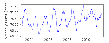
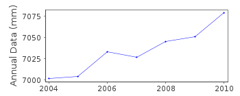
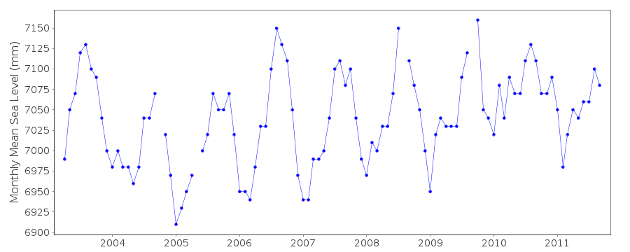
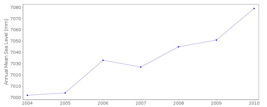
| Time span of data: | 2003 – 2011 |
| Completeness (%): | 91 |
| Date of last update: | 24 Jan 2013 |
| Green Arrow: | Current Station |
| Yellow Marker: | Neighbouring RLR Station |
| Red Marker: | Neighbouring Metric Station |
Please note: In many cases, the station position in our database is accurate to only one minute. Thus, the tide gauge may not appear to be on the coast.
Tide Gauge Data
Station Documentation
Link to RLR information.Documentation added 2011-01-24
Granadilla is a new station on the island of Tenerife first data 2003. Gaugeis a MIROS radar sensor.Data has previously been supplied but latitude and
longitude only now confirmed. Benchmark AP1 3.850m relative to
datum REDMAR .Station made RLR. RLR year is 2004 factor 5.450m.
See paper B. Perez et al 'Overlapping sea level time series measured using
different technologies: an example from the REDMAR Spanish network'.
Documentation added 2014-04-28
At the request of Puertos del Estado the latitude and longitude has been revised from 28.083333 -16.515000 derived from the previously supplied degrees and minutes value to 28.08528 -16.48964 the position of the MIROS gauge in decimal degrees.Data Authority
Puertos del EstadoÁrea de Conocimiento y Análisis del Medio Físico
Avda. Del Partenón, 10
28042, Madrid
Documentation added 2001-03-06
The Area de Conocimiento y Analisis del Medio Fisico wasformerly known as the Departamento de Clima Maritimo.

![]()
![]()
![]()
