Data
- Obtaining
- Supplying
- High-Frequency
- Bottom Pressure Records
- Other Long Records
- GLOSS/ODINAFRICA Calibration Data
Donate
Donate to PSMSL
Data Notes
- Individual Station Data and Plot Notes
- Referencing the Data Set
- PSMSL Help File
- 2010 Changes to the PSMSL Data Files
Extracted from Database
03 Mar 2025
Station Information
| Station ID: | 2130 |
| Latitude: | 13.428333 |
| Longitude: | 144.796667 |
| Coastline code: | 701 |
| Station code: | 10 |
| Country: | GUAM |
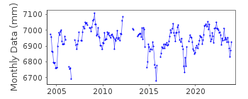
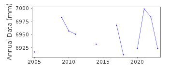
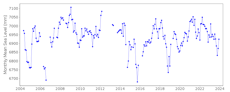
| Time span of data: | 2004 – 2023 |
| Completeness (%): | 84 |
| Date of last update: | 26 Jan 2024 |
| Green Arrow: | Current Station |
| Yellow Marker: | Neighbouring RLR Station |
| Red Marker: | Neighbouring Metric Station |
Please note: In many cases, the station position in our database is accurate to only one minute. Thus, the tide gauge may not appear to be on the coast.
Tide Gauge Data
Additional Data Sources (guide to additional data sources)
Nearby GNSS Stations from SONEL: OGU2, GUUGNearby Real Time Stations from VLIZ: pagb
Research Quality Data from UHSLC station 37: hourly and daily
Station Documentation
Link to RLR information.Documentation added 2012-01-24
Data for Pago Bay, Guam has been downloaded from NOAA as a new station. Data is RLR with Primary benchmark 1428 B 2004 10.000m above TGZ. RLR factor is -0.900m.Data Authority
N.O.A.A. / N.O.S.N/oes33, Ssmc4, Room 6531
1305 East-West Highway
Silver Spring,
MD 20910

![]()
![]()
![]()
