Data
- Obtaining
- Supplying
- High-Frequency
- Bottom Pressure Records
- Other Long Records
- GLOSS/ODINAFRICA Calibration Data
Donate
Donate to PSMSL
Data Notes
- Individual Station Data and Plot Notes
- Referencing the Data Set
- PSMSL Help File
- 2010 Changes to the PSMSL Data Files
Extracted from Database
03 Mar 2025
Station Information
| Station ID: | 2189 |
| Latitude: | 9.425 |
| Longitude: | -84.171667 |
| GLOSS ID: | 167 |
| Coastline code: | 836 |
| Station code: | 21 |
| Country: | COSTA RICA |
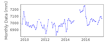
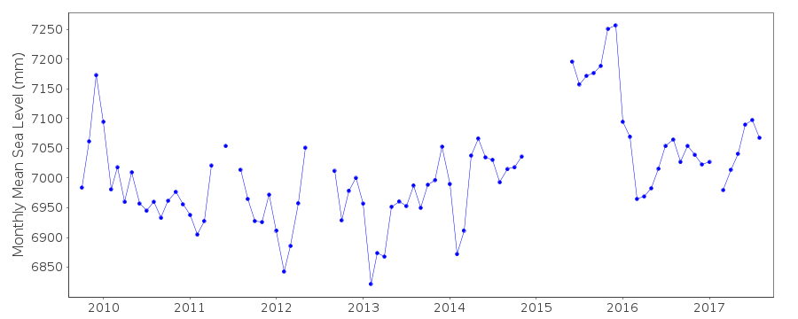
| Time span of data: | 2009 – 2017 |
| Completeness (%): | 77 |
| Date of last update: | 29 Jan 2020 |
| Green Arrow: | Current Station |
| Yellow Marker: | Neighbouring RLR Station |
| Red Marker: | Neighbouring Metric Station |
Please note: In many cases, the station position in our database is accurate to only one minute. Thus, the tide gauge may not appear to be on the coast.
Tide Gauge Data
Additional Data Sources (guide to additional data sources)
Nearby Real Time Stations from VLIZ: quepoFast Delivery Data from UHSLC station 87: hourly and daily
Research Quality Data from UHSLC station 87: hourly and daily
Station Documentation
Link to RLR information.Documentation added 2014-01-16
These data were originally added to Quepos id. 844. Quepos B does not relate to the same reference zero as Quepos.Documentation added 2015-09-29
Using information from the UHSLC levelling sheet Quepos B has been made RLR. It has been confirmed by UHSLC that the gauge ha been moved. The site has been levelled just twice in 2009 and again in 2012. The Primary Benchmark has been confirmed as 2Q which appears on the diagram, but there is only one levelling value for this benchmark. On the RLR diagram I have used 1Q as this has a stable value from both levelling exercises. The diagram can be updated at a later date if further levelling is carried out.Data Authority
University of Hawaii Sea Level CenterDepartment of Oceanography Division of Natural Sciences
1000 Pope Road
Honolulu
Hawaii 96822

![]()
![]()
![]()
