Data
- Obtaining
- Supplying
- High-Frequency
- Bottom Pressure Records
- Other Long Records
- GLOSS/ODINAFRICA Calibration Data
Donate
Donate to PSMSL
Data Notes
- Individual Station Data and Plot Notes
- Referencing the Data Set
- PSMSL Help File
- 2010 Changes to the PSMSL Data Files
Extracted from Database
03 Mar 2025
Station Information
| Station ID: | 2196 |
| Latitude: | 22.246667 |
| Longitude: | 91.825 |
| GLOSS ID: | 36 |
| Coastline code: | 510 |
| Station code: | 26 |
| Country: | BANGLADESH |
| Time span of data: | 2007 – 2018 |
| Completeness (%): | 91 |
| Date of last update: | 29 Jan 2020 |
| Green Arrow: | Current Station |
| Yellow Marker: | Neighbouring RLR Station |
| Red Marker: | Neighbouring Metric Station |
Please note: In many cases, the station position in our database is accurate to only one minute. Thus, the tide gauge may not appear to be on the coast.
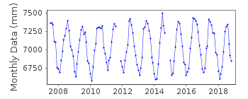
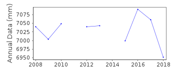
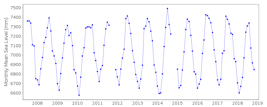
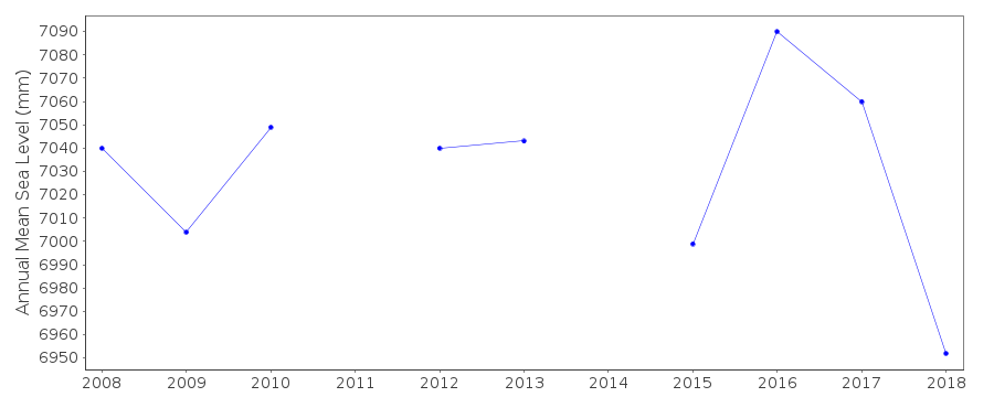
Tide Gauge Data
Additional Data Sources (guide to additional data sources)
Nearby Real Time Stations from VLIZ: chttFast Delivery Data from UHSLC station 124: hourly and daily
Research Quality Data from UHSLC station 135: hourly and daily
Research Quality Data from UHSLC station 124: hourly and daily
Station Documentation
Link to RLR information.Documentation added 2014-01-30
This is a new UH gauge. Data begins 2007 and cannot be linked with the previous historic data.Documentation added 2015-06-30
Using information from the UHSLC levelling sheets Chittagong A has been made RLR.Documentation added 2015-10-15
Complete dataset 2007-2014 loaded from the latest JASL informationData Authority
University of Hawaii Sea Level CenterDepartment of Oceanography Division of Natural Sciences
1000 Pope Road
Honolulu
Hawaii 96822

![]()
![]()
![]()
