Data
- Obtaining
- Supplying
- High-Frequency
- Bottom Pressure Records
- Other Long Records
- GLOSS/ODINAFRICA Calibration Data
Donate
Donate to PSMSL
Data Notes
- Individual Station Data and Plot Notes
- Referencing the Data Set
- PSMSL Help File
- 2010 Changes to the PSMSL Data Files
Extracted from Database
11 Mar 2024
Station Information
| Station ID: | 2234 |
| Latitude: | 43.404935 |
| Longitude: | 4.892935 |
| Coastline code: | 230 |
| Station code: | 45 |
| Country: | FRANCE |
| Time span of data: | 2006 – 2023 |
| Completeness (%): | 67 |
| Date of last update: | 30 Jan 2024 |
| Green Arrow: | Current Station |
| Yellow Marker: | Neighbouring RLR Station |
| Red Marker: | Neighbouring Metric Station |
Please note: In many cases, the station position in our database is accurate to only one minute. Thus, the tide gauge may not appear to be on the coast.
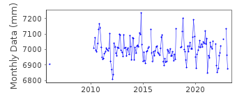
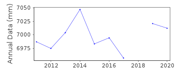
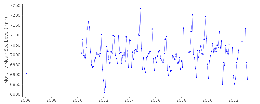
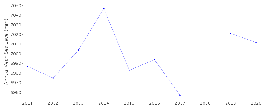
Tide Gauge Data
Additional Data Sources (guide to additional data sources)
Nearby GNSS Stations from SONEL: PALINearby Real Time Stations from VLIZ: ptbc2, ptbc
Station Documentation
Link to RLR information.Documentation added 2016-06-21
Fos sur Mer data begins in May 2010. The station is between approximately halfway between Sete and Marseille. When adding the 2015 dataset it was noted that the datapoints for November-December 2011 had been revised.Data Authority
SHOM13 rue de Chatelier
29200 BREST

![]()
![]()
![]()
