Data
- Obtaining
- Supplying
- High-Frequency
- Bottom Pressure Records
- Other Long Records
- GLOSS/ODINAFRICA Calibration Data
Donate
Donate to PSMSL
Data Notes
- Individual Station Data and Plot Notes
- Referencing the Data Set
- PSMSL Help File
- 2010 Changes to the PSMSL Data Files
Extracted from Database
11 May 2026
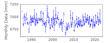
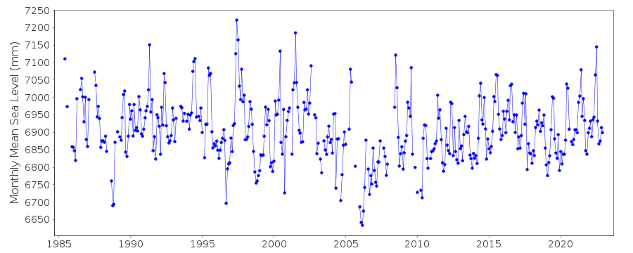
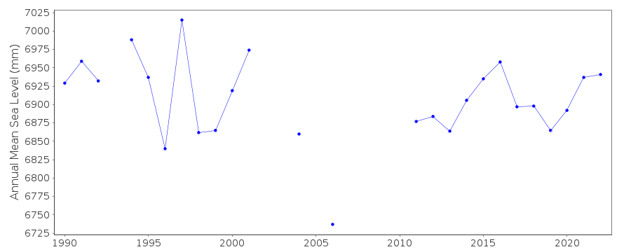
Station Information
| Station ID: | 2262 |
| Latitude: | -39.878333 |
| Longitude: | -73.422778 |
| Coastline code: | 850 |
| Station code: | 48 |
| Country: | CHILE |
| Time span of data: | 1985 – 2024 |
| Completeness (%): | 89 |
| Date of last update: | 09 Jun 2025 |
| Green Arrow: | Current Station |
| Yellow Marker: | Neighbouring RLR Station |
| Red Marker: | Neighbouring Metric Station |
Please note: In many cases, the station position in our database is accurate to only one minute. Thus, the tide gauge may not appear to be on the coast.
Tide Gauge Data
Additional Data Sources (guide to additional data sources)
Nearby GNSS Stations from SONEL: NIEBNearby Real Time Stations from VLIZ: corr, corr2
Station Documentation
Link to RLR information.Documentation added 2015-07-13
PSMSL aready has a short dataset for Corral id.2262 data is for 1963-64. This permanent station was established in 1984.Documentation added 2016-10-11
Using information supplied by SHOA Corral II has been made RLR. Primary benchmark is BM 06 2.970m above the gauge zero. RLR factor is 5.830m.Data Authority
Hydrographic and Oceanographic Service of the Chilean NavyErrazuriz 254
Playa Ancha
Valparaiso

![]()
![]()
![]()
