Data
- Obtaining
- Supplying
- High-Frequency
- Bottom Pressure Records
- Other Long Records
- GLOSS/ODINAFRICA Calibration Data
Donate
Donate to PSMSL
Data Notes
- Individual Station Data and Plot Notes
- Referencing the Data Set
- PSMSL Help File
- 2010 Changes to the PSMSL Data Files
Extracted from Database
03 Mar 2025
Station Information
| Station ID: | 2283 |
| Latitude: | 50.543862 |
| Longitude: | -3.492145 |
| Coastline code: | 170 |
| Station code: | 154 |
| Country: | UNITED KINGDOM |
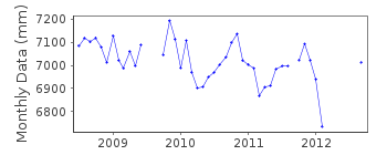
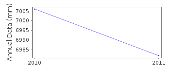
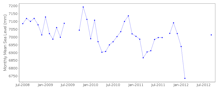
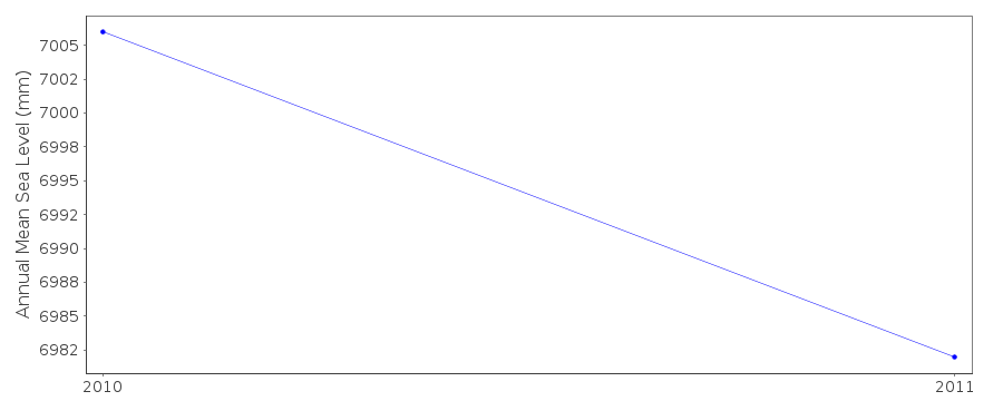
| Time span of data: | 2008 – 2012 |
| Completeness (%): | 68 |
| Date of last update: | 08 Mar 2016 |
| Green Arrow: | Current Station |
| Yellow Marker: | Neighbouring RLR Station |
| Red Marker: | Neighbouring Metric Station |
Please note: In many cases, the station position in our database is accurate to only one minute. Thus, the tide gauge may not appear to be on the coast.
Tide Gauge Data
Additional Data Sources (guide to additional data sources)
Nearby GNSS Stations from SONEL: EXMONearby Real Time Stations from VLIZ: exmt
Station Documentation
Link to RLR information.Documentation added 2016-02-03
Teignmouth is a new station operated by the Channel Coastal Observatory (CCO) based at NOC Southampton. Istrument type is a Rosemount WaveRadar Rex. The datum of the data is Admiralty Chart Datum (ACD) 9.263m below Primary benchmark TGBM. Sampling interval is 10mins. The tide gauge was de-commissioned in February 2014 following storm damage.Data Authority
National Oceanography CentreWaterfront Campus
European Way
Southampton

![]()
![]()
![]()
