Data
- Obtaining
- Supplying
- High-Frequency
- Bottom Pressure Records
- Other Long Records
- GLOSS/ODINAFRICA Calibration Data
Donate
Donate to PSMSL
Data Notes
- Individual Station Data and Plot Notes
- Referencing the Data Set
- PSMSL Help File
- 2010 Changes to the PSMSL Data Files
Extracted from Database
03 Mar 2025
Station Information
| Station ID: | 2299 |
| Latitude: | 56.246667 |
| Longitude: | -134.646667 |
| Coastline code: | 821 |
| Station code: | 33 |
| Country: | UNITED STATES |
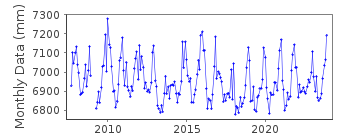
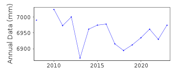
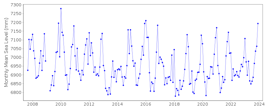
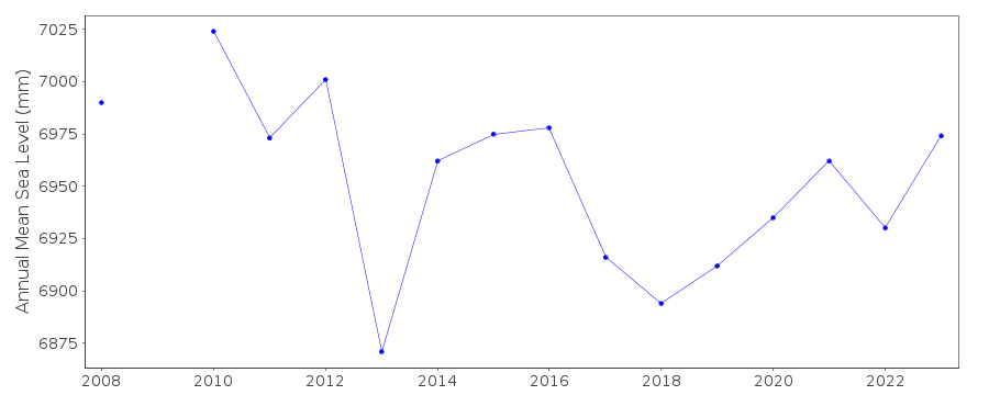
| Time span of data: | 2007 – 2024 |
| Completeness (%): | 95 |
| Date of last update: | 23 Jan 2025 |
| Green Arrow: | Current Station |
| Yellow Marker: | Neighbouring RLR Station |
| Red Marker: | Neighbouring Metric Station |
Please note: In many cases, the station position in our database is accurate to only one minute. Thus, the tide gauge may not appear to be on the coast.
Tide Gauge Data
Additional Data Sources (guide to additional data sources)
Nearby GNSS Stations from SONEL: AB48Nearby Real Time Stations from VLIZ: paak, paak2
Station Documentation
Link to RLR information.Documentation added 2016-04-26
Port Alexander, Alaska is a newly downloaded NOAA station. The Primary benchmark does not have a name on the NOAA benchmark sheets but the designation is given as 945 1054 TIDAL 1. Several Alaskan stations have been newly downloaded from the NOAA website to help with the Quality Control of the data (buddy check).Documentation added 2019-02-05
Data for Port Alexander for Feb/Mar 2017 have been revised.Data Authority
N.O.A.A. / N.O.S.N/oes33, Ssmc4, Room 6531
1305 East-West Highway
Silver Spring,
MD 20910

![]()
![]()
![]()
