Data
- Obtaining
- Supplying
- High-Frequency
- Bottom Pressure Records
- Other Long Records
- GLOSS/ODINAFRICA Calibration Data
Donate
Donate to PSMSL
Data Notes
- Individual Station Data and Plot Notes
- Referencing the Data Set
- PSMSL Help File
- 2010 Changes to the PSMSL Data Files
Extracted from Database
03 Mar 2025
Station Information
| Station ID: | 230 |
| Latitude: | -34.715903 |
| Longitude: | 135.870011 |
| Coastline code: | 680 |
| Station code: | 431 |
| Country: | AUSTRALIA |
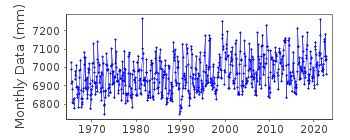
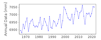
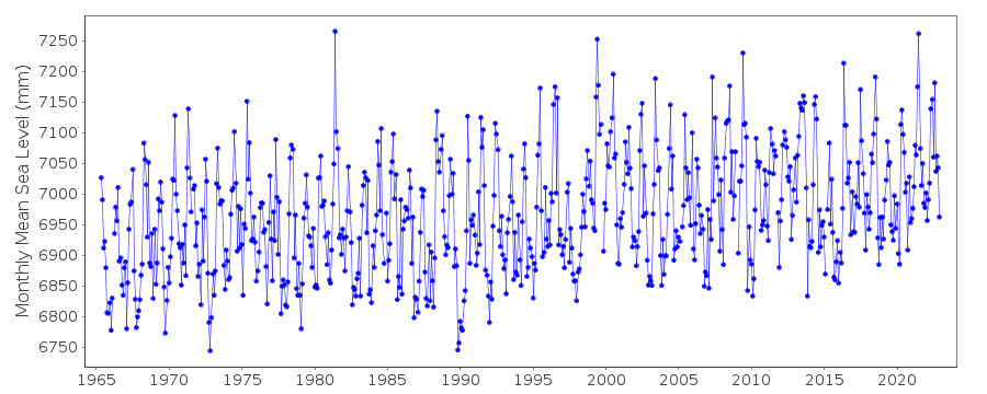
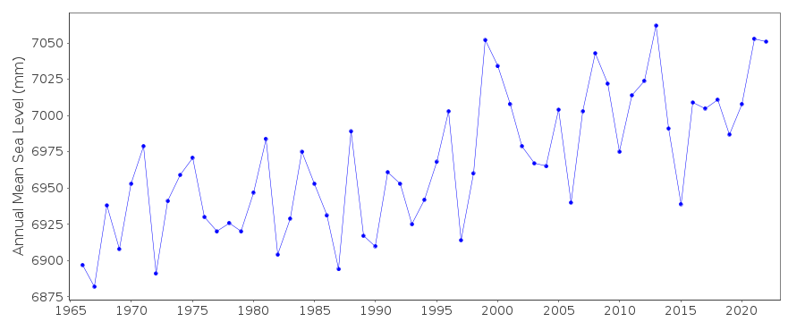
| Time span of RLR data: | 1965 – 2022 |
| RLR completeness (%): | 98 |
| Time span of metric data: | 1920 – 2022 |
| Metric completeness (%): | 60 |
| Date of last update: | 01 Feb 2024 |
| Green Arrow: | Current Station |
| Yellow Marker: | Neighbouring RLR Station |
| Red Marker: | Neighbouring Metric Station |
Please note: In many cases, the station position in our database is accurate to only one minute. Thus, the tide gauge may not appear to be on the coast.
Tide Gauge Data
Station Documentation
Link to RLR information.Documentation added 1995-05-02
Station density along some sections of the Australian coast has meant that station codes 601 onwards have been re-ordered compared to those in earlier versions of the PSMSL data set.Documentation added 1996-05-17
Data up to 1964 was supplied by the Department of Marine and Harbours, Adelaide.Revised data for 1964-1985 was supplied by the National Tidal Centre, Bureau of Meteorology, South Australia.Documentation added 2011-10-20
Using information from the National Tidal Centre, Australia Port Lincoln has been made RLR from May 1965 onwards. Data prior to this was not made RLR as it is not included on the National Tidal Centre website. The benchmark does not have a name/number but is described as 'Bolt in concrete at base of flagpole at Harbor Master's office'. Datum is chart datum 4.610m below TGBM. RLR factor is 6.090m.Data Authority
National Tidal CentreBureau of Meteorology
PO Box 421
Kent Town 5071
South Australia
Documentation added 2010-08-12
Formerly known as the National Tidal Facility

![]()
![]()
![]()
