Data
- Obtaining
- Supplying
- High-Frequency
- Bottom Pressure Records
- Other Long Records
- GLOSS/ODINAFRICA Calibration Data
Donate
Donate to PSMSL
Data Notes
- Individual Station Data and Plot Notes
- Referencing the Data Set
- PSMSL Help File
- 2010 Changes to the PSMSL Data Files
Extracted from Database
13 Jul 2026
Station Information
| Station ID: | 235 |
| Latitude: | 42.353333 |
| Longitude: | -71.053333 |
| Coastline code: | 960 |
| Station code: | 171 |
| Country: | UNITED STATES |
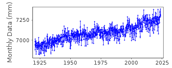
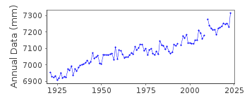
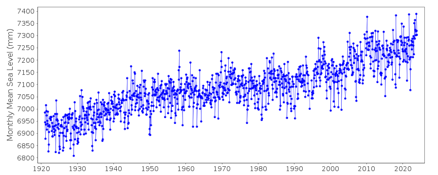
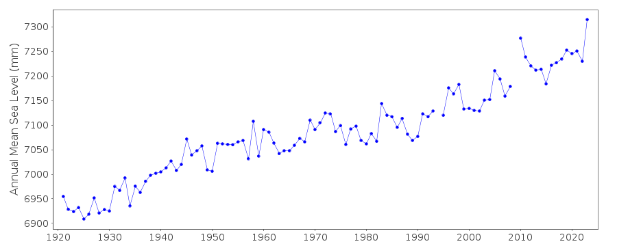
| Time span of data: | 1921 – 2025 |
| Completeness (%): | 99 |
| Date of last update: | 27 Jan 2026 |
| Green Arrow: | Current Station |
| Yellow Marker: | Neighbouring RLR Station |
| Red Marker: | Neighbouring Metric Station |
Please note: In many cases, the station position in our database is accurate to only one minute. Thus, the tide gauge may not appear to be on the coast.
Tide Gauge Data
Additional Data Sources (guide to additional data sources)
Nearby GNSS Stations from SONEL: MAMINearby Real Time Stations from VLIZ: boma
Research Quality Data from UHSLC station 741: hourly and daily
Station Documentation
Link to RLR information.Documentation added 1991-06-11
Boston 960/171 RLR(1964) is 11.0m below BM7Documentation added 2011-08-17
Using NOAA data the RLR diagram was re-drawn. Primary benchmark is now K 12 MASS G.S. 1936 14.292 6.858m above gauge datum. Previous benchmark BM 7 is no longer listed on the NOAA site.Data Authority
N.O.A.A. / N.O.S.N/oes33, Ssmc4, Room 6531
1305 East-West Highway
Silver Spring,
MD 20910

![]()
![]()
![]()
