Data
- Obtaining
- Supplying
- High-Frequency
- Bottom Pressure Records
- Other Long Records
- GLOSS/ODINAFRICA Calibration Data
Donate
Donate to PSMSL
Data Notes
- Individual Station Data and Plot Notes
- Referencing the Data Set
- PSMSL Help File
- 2010 Changes to the PSMSL Data Files
Extracted from Database
03 Mar 2025
Station Information
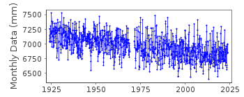
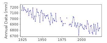
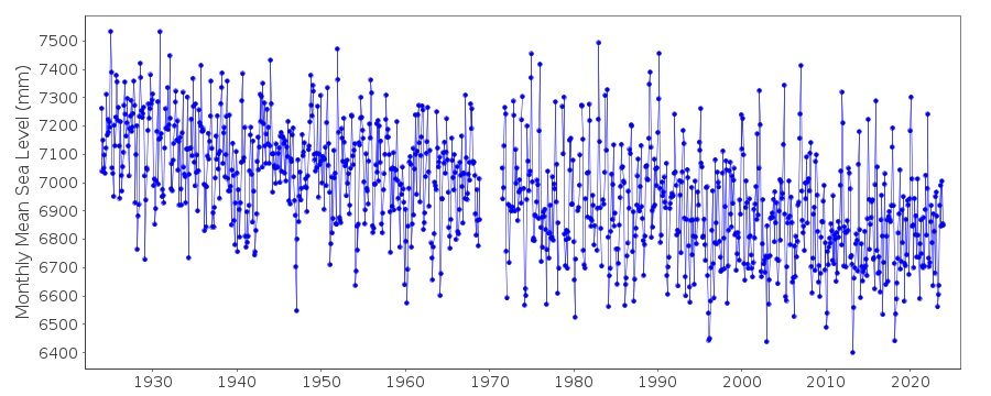
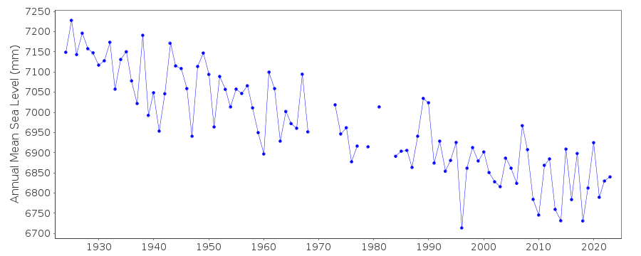
| Station ID: | 249 |
| Latitude: | 60.031883 |
| Longitude: | 20.384817 |
| Coastline code: | 60 |
| Station code: | 281 |
| Country: | ÅLAND ISLANDS |
| Time span of data: | 1923 – 2024 |
| Completeness (%): | 95 |
| Date of last update: | 17 Feb 2025 |
| Green Arrow: | Current Station |
| Yellow Marker: | Neighbouring RLR Station |
| Red Marker: | Neighbouring Metric Station |
Please note: In many cases, the station position in our database is accurate to only one minute. Thus, the tide gauge may not appear to be on the coast.
Tide Gauge Data
Station Documentation
Link to RLR information.Documentation added 1991-06-11
Degerby 060/281 RLR(1964) is 9.5m below BM1849CDocumentation added 1993-07-12
Degerby 060/281 RLR(1964) is 9.5m below BM1849CDocumentation added 2002-09-24
A description of the sea level network in Finland can be foundin 'Operational Oceanography: Implementation at the European
and Regional scales. 2002 (pp.129-137)'.
PRIOR TO 1971FCODE=06
Documentation added 2012-01-03
This station is now more commonly referred to as Foglo. Former Primarybenchmark 1849 c is now no longer used. Benchmark 73125 3.355m relative to
gauge datum was added in 1973. While benchmark 75400 3.964m relative
to gauge datum was added in 1975.
Documentation added 2019-11-27
From 2018 onwards the averages of the Finnish sea level data will be based on 1 min observations. Values are calculated in Finnish normal time (EET).The data are relative to the reference surface of the Finnish sea level observations and thus the datum is the tide gauge zero.
Data Authority
Finnish Meteorological InstituteMarine Research, Waves and Sea Level
Erik Palenin aukio 1
P.O. Box 503
FI - 00101 Helsinki

![]()
![]()
![]()
